Understanding the Terroir of Burgundy Part 4.5, Soil retention – the farming of Burgundy in the 1800s

Ancien Régime

A historical explanation for Les Damaudes’ retention of clay


Click to enlarge. Many thanks to Steen Ohman, of Winehog.org for supplying the Cadastre map of 1827
Click to enlarge. Many thanks to Steen Ohman, of Winehog.org for supplying me with the Cadastre Map of 1827

Changes in parcel division and parcel orientation

While there is no specific information regarding the history of Les Damaudes prior to 1952, the cadastre map of 1827* indicates that the vineyard was planted to vine at that time and that it’s division and orientation was very different in 1827 than it is today. This map indicates that at some point between 1927 and 1952, there was a total reorganization of both parcels and ownership. This reorganization also suggests that the owners of the parcels had abandoned this land. Had there been a continuity of ownership, there would be at least some continuity of plot divisions. Instead, the study plot cleaves through multiple plots shown in the 1927 cadastre.

The Ouvrée, the balk, and soil preservation

Many of the plots indicated by the map, were very small. The size itself is indicative of ownership by peasant farmers.  These small parcels were the remnants of the ancien régime; the open field system that created and dictated the agricultural fabric of France for over seven centuries. At the time of the revolution, a full third of Burgundian agricultural land was farmed under the manorial system and was converted to peasant ownership. (Loutchisky 1911)

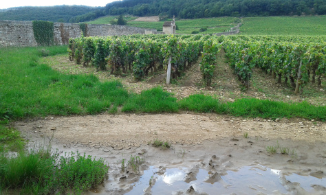
Additionally, some of the larger parcels of Les Damaudes were oriented horizontally to the slope, so the rows followed the hillside.  These parcels were large enough and long enough to suggest they may have been plowed. These larger plots were traditionally sized by the amount land a man could work in a day with a pair of plow animals, were measured in ouvrées.(1) These larger plots, with their long, narrow horizontal orientation would not have allowed nearly the high rate of erosion as similarly sized vertical plantings of today do. Secondly, because these horizontal plots were relatively narrow, erosion was again curtailed, as storm water runoff would have been slowed by these closely spaced divisions.


paysan

All across Europe, serfs and villeins (freeman tenants) (2)  tended their plots, known as selions, just as they had for over seven centuries. Selions were traditionally divided by a raised, strip of fallow land called a balk indicating the end or beginning of one man’s plot and the beginning of another. The word balk (to pause or not proceed) originated from this practice of plot division.

Any break in vineyard planting, like plot divisions, roads, and walls, all have been shown to slow runoff by diminishing its velocity, thus easing the pressures of erosion.  So the small size of these parcels alone would have deterred erosion, but if these plots were additionally bordered by any kind of balk, these would obstacles would have minimized the velocity of the runoff. There is evidence that balks did exist in Burgundian vineyards, as Jim Busby Esquiredescribes walking along “grassy footpaths” while visiting the vineyard of Chambertin in 1840.  It is reasonable to conclude the small parcel divisions of Damodes, each likely separated by a balks or footpaths, were huge contributors to the fact that such a high percentage of clay was retained in this steep vineyard.

One foot in feudalism

At the time of the Revolution, feudalism, although waning, still existed in various forms. So on the heels of the French Revolution in 1789, when the National Assembly released all of the demesne (domaines) of King Louis XVI, the serfs and freemen tenants who farmed these lands were given the title of the plots they had farmed before the Revolution. This action would affect a quarter of the farmland in France, although in Burgundy this figure was higher. The royal demesne constituted 35% of the agricultural land in Burgundy at the time of the revolution, while it is estimated that church held the title of an additional 11% to 15% (Loutchisky 1911). This acts also released France’s 150,000 serfs, almost all of which had belonged to the Church. (Sée 1927)

Initially, the peasants were to pay for the release of seigneurial dues, but as the peasants could not pay with money they did not have, these release fees were withdrawn by the National Assembly in 1793. With a mere 38 years separating the revolution and the production of the 1827 cadastre map, it is likely that some of the owners of these plots had been former villien (freeman tenants) and were still working plots they had gained because of the revolution.(3)  

*For additional explanation of feudalism see Part 4: The history of erosion and man.

After the dissolution of traditional "demesne," or domaines of the Marquis and the church, peasants were given the rights to the land that they had always farmed as serfs. These parcels were called selions. After the phylloxera destroyed their vineyards, many of these peasant owners could not afford to replant their vineyards. A number of these lesser vineyards were not replanted for almost a century. Here an Image of a peasant girl resting, is from the Paris Salon circa 1893.
After the dissolution of traditional “demesne,” or domaines of the Marquis and the church, peasants were given the rights to the land that they had always farmed as serfs. These parcels were called selions. After the phylloxera destroyed their vineyards, many of these peasant owners could not afford to replant their vineyards. A number of these lesser vineyards were not replanted for almost a century. Here an Image of a peasant girl resting is from the Paris Salon circa 1893.

Although they were now landowners, rather than landholders, the peasant’s lot had not significantly changed. The wealthiest of them could earn a living off of the land as farmers, either on their own or in co-op with others as métayers. Many continued to struggle for sustenance, working also as day laborers, or worked a side trade (Henri Sée 1927).

In some ways, many of farmers were to be worse off for it for the dissolution of the feudal system, which through its evolution, had allowed significant freedom, and did not generally entail servitude. Additionally, the dues owed by the tenant farmers were far less burdensome than they had been in the middle ages, consisting of rent and a few days of compulsory labor on the nobles demesne (Sée 1927). Within this feudal framework, the Seigneur provided communally shared horses and plows, which all laborers used to make the work their fields.

With the removal of the feudal system, the peasant needed to provide his own tools, and that included the use of any plow animal.

A pair of oxen cost 300 to 400 francs at the time Busby visited France in 1840, and for all but the wealthiest peasants, this was an unfathomable price to pay for an animal.  Plows were also an expensive piece of equipment. Since a man with a pair of plow animals could work roughly six to eight times the area, than a man without one, the loss of access to a horse and plow predictably would have significant implications for the peasant farmer.  They now must attempt to use a shovel and hoe to try to farm the same area of land they had as a villein using the seigneur’s horse and plow. This loss of productivity (in terms of area) would require the peasants to either hire workers to help work their fields or sell (or lease) land they were not physically able to work by hand. If there was a positive side to this, having to hand-work these small plots was an additional factor in the preservation clay in the vineyard of Les Damaudes.

24,000 or more vines per hectare

It was either the small size of plots or the inability to buy plow animals (or both), that encouraged Burgundy’s farmers to literally fill every empty space of a vineyard with vines. It was common at the time, for Burgundian vineyards to achieve planting densities of 24,000 to 30,000 vines per hectare.

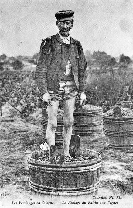
When visiting the great vineyard of Chambertin, James Busby recorded that in the half-hectare plots there,  a mere 15 inches of spacing existed between each vine. This was true not only between plants within a single row but between rows as well. Busby wrote that “The plants were literally crowded to such a degree, that it was almost impossible to set down the foot without treading upon some of them.” It would be seemingly impossible to plow a vineyard with such spacing, which meant all vineyard work would have to be accomplished with a hoe.

provignage illustrationThe peasant would achieve this enormous number of vines, essentially for free, by a technique called layering or provignage. This was the poor man’s answer to using cuttings, which were by then, being bred in nurseries from clones scientist had discovered to be resistant to various diseases. The cuttings were however very expensive and often used sparingly even by more wealthy land owners, only one cutting used for every three vines established. The other vines would be grown via provignage from the purchased cutting.

To perform layering or provignage, a trench was dug from a healthy plant to the location where the farmer wanted to establish a new plant.  He would then bury a cane or shoot of the vine into the furrow he had dug, with a layer of manure and then cover this with soil. Over the course of the next year, the buried cane (shoot) would develop roots of its own, and the vigneron would separate the two vines by cutting off the cane that started the new plant. Alternately, the two vines could be left adjoined, and in many places, there could be several of these Siamese vines connected to one another. The vineyardist would attempt to regulate the rows to be as straight as possible, but layering created such irregularity that Busby recalled that “it would have been very difficult to point out which way the alignment lay. For this purpose, the stocks and roots were twisted, and the different plants laid across each other in every possible direction.”

for a poor man, the game, or, as it was generally called, the large plant, was undoubtedly the best kind of vine, the quantity it yielded was so much greater than the other; and, to a poor man, the quality was not so much an object, for the large proprietors and merchants would never acknowledge his wine to be a fine one, and it was very difficult to sell it for a high price, however good.”
Journal of a Recent Visit to the Vineyards of Spain and France, James Busby Esq. 1840

According to Busby, a plant grown by provignage would produce grapes in its first year. However, the vines would become weak in 10 to 15 years time and would need to be replaced. This meant the 19th-century vineyard was in constant state tearing out and replanting.  In vineyards such as Chambertin, which produced exponentially more expensive wine, the vineyard owner could often afford lay fallow sections in which vines were removed. These fallow areas were then planted to sainfoin,  a cover crop that could be used to feeding horses, while simultaneously rejuvenating the soil with nitrogen that had been depleted by overcrowding the field (domaine in French) with vines. This alternate use would last for four years, and represented a significant cost, and could only be sustained by a vineyard that produced a wine that fetched high prices in the marketplace. This would not have been true of a vineyard such as Les Damaudes.

It is clear, that as of 1860, there were many vineyards in which the soils were still in relatively good shape, because of the farming methods of the time. There has been some historical record of vineyards, as early as the 1600’s, that required their soils to be replaced, (presumably due to rill and gully erosion) to cover exposed base rock. The tremendous expense of bringing in soils indicates that this erosion occurred in larger vineyards owned by a wealthy marquis or another nobleman, the church, or later, a member of the growing bourgeoisie, who would dominate the

sulpher treatmentsThis set the stage for the introduction of phylloxera to France and Burgundy. It would be too simple of a story to phylloxera wiped out the vineyards of France and eventually the vineyards were replanted with root-stock from American hybrids. While most accounts of the phylloxera blight in terms of total dollars lost and businesses going under; as in all economic downturns, there are those who lose everything, and those losses create opportunities for others. And that is the story of Les Damaudes. We know there was a wholesale change of plot ownership and re-organization parcel disbursement in the vineyard, that occurred sometime between 1827 and 1952. While precisely when and how remains a mystery, but there is no doubt that phylloxera played a large role in this story.

Jean-François Millet (1814-1875), Vineyard laborer resting, 1869

When phylloxera arrived on the doorstep of the Côte d’Or in 1775, it was clear that a peasant would not be able to withstand the loss of their vines. The peasant, who depended on every Franc for their day-to-day survival, could not afford the chemicals to treat the vines. They could in no way spend a year’s labor tearing our their vineyard. This was an impossibility. And they certainly could not afford the 3000 Francs per hectare it cost in 1880 to replant the vineyard. It almost seems silly at this point to mention they would not be able to afford to labor in the vineyards for the four years that the young vines would produce no fruit.  If they were lucky they would own other plots of land that produced produce or wheat that could sustain them. Otherwise, these peasants were likely many of the 1 million Frenchmen who would emigrate to Algeria or America in the 1870’s through 1900.

Ironically, as the grape growing peasantry was forced to leave their land in phylloxera affected areas, economically, in France, things were improving. For the unskilled worker, wages increased  2/3’s between 1850 and 1910. During the same period, GDP doubled, despite France’s involvement in the Crimean war and the disastrous Franco-Prussian war of 1870 which saw the fall of the Napoleon III and the second Republic. Likely, it was France’s continued imperial pursuits of colonizing parts of Africa and Asia artificially buoyed they French economy, but whatever the reason, the economic up-turn caused a growth in demand for wine and rising prices, and this promise of demand would justify replanting the most profitable of vineyards immediately.

Hopefully, this long, historical explanation of why the soils of Les Damaudes (and likely those in Cros Parantoux) retained their natural levels of clay, may seem reasonable. In my view, the retention of clay was two-fold.  Number one: the vineyard was farmed in small divided sections, and farmed by hand. Additionally, the larger parcels were oriented horizontally, limiting the distance between plots on the vertical axis. These larger plots or may not have been plowed in the 1800’s; but if they were, because of the plot shape, could only have been done across the slope, following the curve of the hillside. This would have limited erosion. Secondly, like Cros Parantoux, this vineyard likely lay abandoned for a lengthy enough period that ownership of the vineyard was reapportioned. The most obvious period for this to have happened was from the early 1880s when phylloxera struck to 1952 when this parcel was planted.


I defer to Steen Öhman author of winehog.org, who has carefully researched the available history – primarily ownership – of Cros Parantoux . Read his article here.


(1) The Burgundy Report has a breakdown of land that is significantly different than found in the book, Measures and Men Witold Kula  Princeton University Press (1986). Bill Nasson reports that an “Ouvrée is 4.285 ares; the area one man could work in one day” and a “Journal  equals 8 ouvrées, or 860 perches, or 81.900 ares and was the area one man could work in one day with a horse and plough.” This is very different than Kula’s writing that an ouvrée was a vineyard specific measurement that Burgundian used for the area that a man could work with a pair of plow animals, and a journeaux in Burgundy referred specifically to the size of a cornfield a man could work with a pair of plow animals. I was unable to find further supporting evidence for either account.

(2) Serfs of France had largely been “enfranchised” over the course of the middle ages. But this varied on where and when since control of France was spread over various Duchies. To give a general time frame when enfranchisement was occurring, Charles the Fair emancipated the serfs of Languedoc in two letters from 1298 and 1304. Upon gaining freeman status, serfs became villeins (this is where the word villain came from, meaning: scoundrel or criminal). They may have been enfranchised but in many ways, their situation had not changed all that significantly. As tenant farmers, they were still legally bound to the manor where they were tenants. They paid ‘rent’ either in the form of money or produce, and owed the noble of the manor a certain number of days of unfree labor each year, referred to as Corvée. This was simply a form of barter between the tenant and the nobleman. A similar arrangement is the sharecropping agreements referred to as métayage, meaning half.  This is another form of barter agreement, where the lease payment is in the form of a percentage of the product of the vineyard, in either grapes or wine.

(3) The life expectancy in France in 1828 was 37 years, thanks in part to the smallpox vaccinations that began in 1810. Earlier, in the 18th century half of all children died before the age of 10 years old, lowering the average life expectancy in the 1700’s to only 25 years. The period of the Napoleonic Wars, 1803 to 1815, saw a drop in average age to below 30 years. This happened again in 1870 following the disastrous (for France) Franco-Prussian, when the Napoleon III was captured, and Paris would later fall Germans January of 1871, in Bismark’s successful bid for German unification.


Additional reading

A History of French Public Law, Volume 9,  Jean Brissaud p. 317-318 Ulan Press (1923)

Economic and Social Conditions in France During the Eighteenth Century Henri Sée Professor at the University of Rennes 1927

http://press.princeton.edu/chapters/s9479.pdf     European Wine on the Eve of the Railways, James Simpson


Understanding the Terroir of Burgundy: Part 4.2 Erosion: fundamentally changing terroir

Erosion banner


Erosion is constantly changing the terroir of Burgundy, and in turn, it is altering the weight and character of the wines from virtually every vineyard on the Côte. How significant is erosion in Burgundy today? As mentioned in Part 4.1, a study during the late 1990’s measured the soil loss in unspecified vineyards of Vosne-Romanée to be 1 mm per year, and the same erosional levels were measured off of the vineyards of Aloxe-Corton.  Ath that alarming rate, losses over the next century would have averaged 10 centimeters or almost 4 inches of topsoil if corrections were not taken. On the even steeper slopes of Monthelie, a study measured almost twice the erosion at 1.7 mm (± 0.5 mm year), with sections of the vineyard which measured a shocking eroded up to 8.2 mm (± 0.5 mm) erosional rate. Luckily, many growers have improved their farming practices, particularly since 2010, and these figures should be lower today. Only future studies can tell us what improvement has been made.

The grape harvest Annonymous 16th century, Southern Holland
“The grape harvest” Anonymous 16th century, Southern Holland

For centuries the solution for this problem was to bring in soil from outside areas to replace what was lost on the slopes of the Côte d’Or. However, in the name of terroir, this is no longer allowed. Current law allows growers to redistribute only the alluvium that comes to rest within appellation boundaries. One can imagine that the laborious process of shoveling out the alluvium from the toe of the plot and redistributing higher in the vineyard is a yearly chore. What earth escapes the appellation lines however, is gone to that appellation forever.

The intention of preserving the purity Burgundy’s unique terroir by forbidding introduction of exogenous soils is somewhat paradoxical, since it is only attempting to preserve the terroir à la minute. While in reality it is ultimately is failing at that – due to erosion. 

A positive, unintended consequence of this inability to replace soil is that growers have finally realized that soil conservation is now more critical than any time in Burgundies’ 1500+ year-old viticultural history. They now know that they must fully understand the factors of soil structure and erosion, while at a municipal level, their villages must invest in effective storm water management; both of which are in various states of development or improvement. 

The long uninterrupted run of vertically oriented rows presents unrelenting erosional pressures on this section of Les Folatieres.
The long uninterrupted run of vertically oriented rows presents unrelenting erosional pressures on this section of Les Folatières. photo googlemaps

While the best modern practices are stemming the tide of erosion, vineyards still can be threatened. Even great vineyards on the mid-slope, like Les Folatières in Puligny-Montrachet, which have long, open stretches of vines without significant breaks in planting, are prone to extensive erosion. While soils are depleted not only in terms of depth, they are changing in terms of particle size and makeup. Erosion most easily targets fine earth fractions, detaching them from their aggregate groupings, and sending them into vineyards farther down slope. Light to medium runoff acts like a sieve, carrying away only the smallest particles, leaving behind material with of larger particles sizes. This in a very real way changes the vineyard’s terroir, and in turn, the wines that are grown there. Wines from vineyards that retain only course soils of large particle size (1) tend to produce wines with less fruit the and less weight, and by consequence revealing a more structured, minerally character.

Even more critical is that soil loss can threaten the vitality and health of the vines, as the soil is literally carried away from beneath them. A vine’s main framework roots is said to require a minimum 11-13 inches to anchor itself to the earth and survive. The problem arises when a section of vineyard does not have extensive fracturing, and the soil level begins to drop below that one foot level. To address this, various growers have responded by “reconditioning” their land. By using a back hoe to break up the limestone below, this can give new vines planted there the living space so the vineyard can continue. Does this change the terroir and the future wine more than inputs of exogenous soil? I should think the answer is yes, significantly. 


Rainfall and rain strike: the first stage of erosion

rainstrike. photo: agronomy.lsu.edu/

Rainfall is measured by its size and velocity. A raindrop from a drizzle is typically .5 mm in size, and has a terminal velocity (the maximum speed the drop can reach) of 2 meters per second, or 4.5 miles per hour, in still air. The speed it falls, with no assistance from the wind is determined by its ratio of mass to drag. Large raindrops of 5 mm, have more mass in relationship to its drag and accelerate to 9 meters per second, or 20 mph.

Rainfall, meaning the actual physical strike of each drop, can break down soil aggregates (fine sand,  silt clay, and organic materials) and disperse them. Splash erosion has been recorded to drive particles of earth up to 60 cm into the air, and 1.5 m from its point of origin.

Once their limited bonds are broken, the ensuing runoff can carry these materials downslope. Runoff, the most obvious form of erosion, occurs when rainwater cannot infiltrate the soil quickly enough, and exacerbated by the lack of cover crop, lack of organic material, lack of soil structure and negative effects of soil compaction. Of course, this process is most noticeable during high-intensity rainstorms, the amount of soil lost during longer but low-intensity rainfall can be significant. This slower erosion can go largely unnoticed until most of the productive topsoil has been removed by what is referred to as sheet erosion.

Seasonal protection from rainstrike

Compared to most growing regions, the Côte d’Or has a very wet growing season. Storms during this period can bring irregular and unpredictable rain events that can be heavy and long in duration. The winds during harvest tend to be westerly, with warm humid winds bringing rain first over the Hautes Côtes, then to the Côte d’Or, then out across the Saône Valley. The wet warm humid conditions often encourage powdery mildew in the wake of the storms, so there is a tendency to want to prune to open up the canopy for ventilation to prevent mildew. However, the vine canopy can provide significant protection against rainfall strike, depending of course, on the orientation the rows and the of the wind direction. So good canopy coverage for the period that half of the precipitation occurs (April – September)(2) is beneficial in terms of protection from erosion.

As winter arrives, the vines will have lost their foliage, exposing the soil directly for the entire winter and spring to whatever nature has in store.

Rain Rate

storm.1
Summer storms. Bottom right Photograph: Louise Flanagan theGuardian.com, Bottom left photo Caroline Parent-Gros of A.F. Gros, Top photo Decanter.com

Rainfall is typically measured in millimeters per hour, with a light rainfall slightly tipping the scales at up to 2.5 mm per hour or less than a tenth of an inch per hour. Moderate rainfall is considered to be from 2.5 mm per hour to 10 mm per hour. A heavy rainfall falls between the range of 10 to 50 mm, and a violent rainfall is above 50 mm per hour.


Light rain – drizzle 2.5 mm per hour with a terminal velocity of 2 meters per second

Moderate rain 2.5 mm per hour to 10 mm per hour

Heavy Rain  10 mm per hour to 50 mm per hour

Violent rain, above 50 mm per hour


Good soil structure resists damage from rainstrike and runoff

Good soil structure is the result of the binding of soil into clumps of both small and larger aggregates, meaning sections of soil will bind more strongly together, than those next to them. This allows the soil to maintain the necessary small and large pore spacing, which allows water, air and nutrient infiltration and movement through the soil. Larger amounts of older, more stable organic matter tend to strengthen soil aggregates so any farming practice that increases organic matter, and the subsequent microbiological activity will result in healthier soils.  Stable soil aggregates allow the soil to resist disintegration due rain strike and thusly helps deter erosion.  It also encourages root penetration by creating weak spots between aggregate masses.

Conversely, unstable soil aggregates are more easily dispersed by rainstrike, and the ensuing erosion clogs larger pore spaces of the surface soil. This clogging forming hard crusts on the surface which both restricts both air and water absorption and increases runoff.

The fix apparently is simple. According to soilquality.org, soil forms aggregates readily with the addition of organic manure, as well as allowing cover crops to grow, which has the additional benefit of protecting the soil from rain strike and the ensuing erosion.

Infiltration rate

Erosion Runoff Ardeche
Rill Runoff running fast in Ardeche. Photo http://www.geo.uu.nl/

The speed at which rain can be absorbed into the soil is referred to as infiltration rate. An infiltration rate of 50 mm per hour is considered ideal for farming, because even in heavy rainfall, a well-structured loam will not allow puddling. While the farmers of Burgundy do have some loam in their soils, the geological and topographical factors they face are far more and varied and thus more complex than that of the typical farming situation. I could find no studies done specific to infiltration rates of Burgundian soils, but below are the general rain infiltration rates of general soil types, starting with clay.

The infiltration rate of clay soils, with good to average soil structure, unsurprisingly, do not drain all particularly well, due to their very small-sized particles. Clays typically have an IR of 10mm-20mm per hour. And as we know, transported clay, with its aligned particles, and plasticy quality greatly restricts water flow, and while it will absorb water, it will not allow water to pass through until the entire structure is saturated, greatly slowing drainage. Worse, due to poor farming practices, clay soils can have a decayed structure, which can slow absorption to less than 10 mm per hour. Water tends to puddle on clays with poor structure, causing them deteriorate to the point of deflocculation.

The study of water and how it drains is researched acutely in areas where water is scare, whereas little study of drainage is done in France where rain and water are plentiful. Hence, my investigation of water infiltration in calcium-rich soils lead me to agricultural water policy studies conducted in Palestine and Spain. One such study found that Clayey Marl, with a plasticy character, had an infiltration rate of only 4-8 mm per hour. This low rate of infiltration suggests the soil structure had already been degraded through poor farming practices. Often the villain of low infiltration rates is a combination of frequent deep tillage, herbicide and pesticide use and compaction by walking on or working wet soils, which collapses weaken soil aggregates.  In deeper soils, like at the base of the slope, collapsed soil aggregates can result in hardpan development below ground, while on sloped vineyards, disrupted soil aggregates are very susceptible to erosion.

Clay-loam and clayey-marls, like those found on many lower-slope vineyards, that retain good soil structure, have IR rates beginning at 20 mm per hour. As the percentage of loam increases (equal parts sand, silt, and clay) the IR rate increases up to 50 mm per hour as long as it retains good aggregate stability and there is no compaction.

Loam to sandy soils, which some Bourgogne-level and Village-level vineyards possess, can have very good infiltration rates, again as long as soil structures are good.  Ideally, they can absorb 50 mm of rain per hour, which is the amount that a heavy rainstorm will produce. These vineyards, however, receive all the runoff from the slopes above, and their “well-drained” soils can be overwhelmed.

Sandy soils and Calcareous (limestone) soils can have infiltration rates well in excess 150mm per hour to 200+mm per hour. The problem is these soils drain excessively well, and tend to not retain water well, and are prone to high evaporation rates.  Off point, but quite interesting, are two studies in south-eastern Australia Bennetts et al. (2006) and Edwards & Webb (2006) found that rainwater remained relatively unchanged as it moved though these porous soils that lacked significant amounts of fine earth fractions and organic material. However, water changed its chemical signature quite significantly as it passed much more slowly through clay-rich soils. This finding certainly challenges the long-held assumption that it is the limestone lends many Burgundies their mineral character.

Infiltration Rate, Slope, and Runoff.

Vogue's parcel of Musigny. Source Googlemaps
Vogue’s parcel of Musigny. Grass growth does not seem to be encouraged here. Given Cerdà’s study regarding the erosion of bare soils, one can only wonder how much greater this vineyard could be? The mitigating factor is the vineyard runs horizontally along the top of the hill, and is not deep or highly sloped. Runoff has little opportunity to gain significant suspension velocity. Photo Source googlemaps.com

A study in Spain by A. Cerdà (Univ. de València) examined infiltration rates, runoff, and erosion, on clay, marl, limestone and sandstone. Additionally, he ran these trials with three levels of vegetation covering the soil material: bare, intermediate and vegetated.  The amount of water delivered was 55 mm per hour (which some soils easily absorbed). The study showed slower rates of infiltration on the bare soils, while more highly vegetated soils reduced and almost eliminated runoff and erosion.  Interestingly, marl soils fare the worst for both runoff and erosion rates on bare soils. Yet on vegetated soils, runoff and erosion of the marl were minimal.

They observed, of bare soils, an infiltration rate of  3 to 55 mm per hour, the runoff from 0 to 83%, and the erosion rates from 0 to 3720 grams per hour.

The easily erodible marl soils had up to 83% runoff and a maximum erosion of 3720 grams per hour. So it turns out that marl soils are particularly vulnerable to erosion which sets up an interesting dichotomy: Burgundian’s penchant for discouraging ground cover between the vines, actually encourages erosion – something they seek to, and direly need to avoid.

Clay (soil) and limestone (soil) both had what Cerdà considered to be intermediate levels of runoff and erosion; with a maximum of 46% runoff, and a maximum of 131 grams of soil material eroded per hour.

When we talk about erosion, we are implying there is a slope.

Nearly level: Level, 0% Nearly level <3%
Gently sloping: Very gently sloping >1%, Gently sloping <8%
Strongly sloping: Sloping >4%, Moderately sloping <8%, Strongly Sloping <16%

Source: nrcs.usda.gov

On the rockier terrain of upper slopes, the uneven the soil surface can slow the momentum of water coming down the hillside, despite the steeper grade. However, as the runoff moves downslope, and the soil becomes smoother, the water grows in volume as in joins other rainfall which has not yet infiltrated the topsoil. This increase in volume causes the runoff to increase in its speed and its velocity. Speed and velocity increases are exponential, as its mass allows it overcomes the friction of moving over the soil below. 

Despite the fact that these moderate slopes can attain fairly significant soil depth with normal, moderate rainfall, they are also prone to erosion when exposed to heavier storm-induced runoff. Any long, uninterrupted stretch across these moderate slopes encourages a fast, and often damaging, runoff. As the speed of the water increases, it achieves a volume sufficient to carry larger and larger particles. Cerdà’s study suggests that the marl that has developed on these slopes are particularly vulnerable to heavy runoff if no vegetative cover is allowed to grow among the rows. 

Suspension velocity

water suspension velocity
water suspension velocity source: water.me.vccs.edu/

The ratio of surface area to weight determines a soil particle or rock’s suspension velocity. This is the amount of water velocity needed to carry the object in its flow. As the flow decreases, rocks with higher suspension velocity, meaning they require fast-moving water to carry them, settle out quickly, and are said to have a low settling velocity. As the water slows, it is these, the densest objects, that fall out of suspension first.

Silt and Clay particles have a very low suspension velocity due to their extremely small size, regardless of their density. These particles are easily picked up and washed away by water movement. Unless the clay particles in suspension are adsorbed as it slowly passes a homogeneous clay body (ie. a kaolinite clay body attracts kaolinite clay particles and illite particles will flocculate with an illite body), clay particles will not settle out of solution until the water becomes still and ponds. The same is true with silt, with its slightly larger particle size.

Sand and gravel are larger, with enough density to resist slow-moving water. They are considered to have a higher suspension velocity than silt or clay. But neither sand, gravel, nor even rocks the size of the palm of your hand, are immune from alluvial transport.

Up next: Erosion 4.3 In the water’s path: Studies of Erosion in Vosne


(1) It could be argued that because of Burgundy’s monoculture and high erosion rates will only allow calcisol, and because of that soil development (pedogenesis) is not possible due to the filtering out of fine particles, both mineral, and organic, by erosional processes. Conservation tilling or zero till could greatly change that dynamic, and it is possible with these and other techniques, that growers could expose the truer terroir of Burgundy.

(2) The Wines of Champagne, Burgundy, Eastern and Southern France,  by John J. Baxevanis Rowman & Littlefield Publishers (October 28, 1987)

(3) Could this chemical signature change the flavor of wine? This certainly raises a whole host of questions regarding the impact of fast draining limestone on the flavor or minerality of in wine. This study would suggest the long-held belief by many that limestone gives wines a minerally characteristic is false.


Understanding the Terroir of Burgundy: Part 4.1 the history of erosion, defense, and restoration

Erosion and man


Historical vineyard defense and restoration


During the late 1990’s and early 2000’s, soil measurements in both Vosne-Romanée and Corton determined that the erosion rate for both areas were approximately 1 mm per year. Considering that the entire Vosne hillside, as well as all of the hill of Corton are either premier or grand cru sites of enormous value, one would have assumed that every effort had been made to limit erosion. But that assumption would not have been completely true.


Even now, 15 years later, with ever-improving an information, and a growing acceptance that erosion is significant problem that needs to be further addressed, not every farmer is making the necessary changes. While soil management may not be ideal in every plot, vast improvements have been made from the time of the Middle Ages, when erosion ravaged vineyards of the Côte d’Or.

One of Vogue's parcels of Musigny denuded of all grass. While there is no denying the quality of the wine today, what of the vineyard in the future? photo: googlemaps
One of Vogue’s parcels in Les Musigny, denuded of all grass. While there is no denying the quality of the wine today, what of the vineyard in the future? photo: googlemaps

Man has waged an epic war against erosion for centuries; which, until recently, has been largely futile. The early Burgundians were understandably ignorant of soil structure and proper tillage techniques, both factors that greatly mitigate erosion. They had no way to know that it was the way they farmed that actually caused the huge erosional problems they fought so unsuccessfully to reign in.

Change, in an old, tradition-bound culture is resisted; and that is nearly as true in Burgundy today as it was in the middle ages. New techniques such as conservation tillage can be very slow to be adopted, much less having a discussions with older generation about whether a vineyard should be tilled at all. That this ancient practice of zero tillage has been implemented with success in other areas as long ago as 1971, is of no consequence.

Many farmers still restrict the growth of ground cover by use of either pesticides and or routine tilling, both of which diminish soil structure and increase exposure to erosional factors. This can be seen even in Comte de Vogue’s perfectly neat parcels of Les Musigny, where only a few tufts of grass evade the plow blade or the hoe. While it is difficult to argue with Vogue’s results in the bottle, the unseen menace of sheet erosion exists robbing the soil of fine earth fractions, ever so slowly.(1)

Before global warming, the vines were planted in Burgundy in east-west rows, straight down the slope. This directional planting was done in belief that it opens the vines to the early morning sun, allowing better ripening. Unfortunately, any truth to this is offset by increased erosion. While the weather was often predictably cold, and complete ripening could be hit or miss, the soil is a not a renewable resource. As we examined in Part 4, soil lost over 6,000 years ago from the hillsides of central France at the hand of Neolithic men, still has not, and in all likelihood, will never really repair itself.

Burgundy’s historical defense of the vineyard

flooding gate
photo: Caroline Parent-Gros

Murgers, or stone walls, have historically been the farmers first, and perhaps only, line of defense since antiquity.  Murgers (or Clos if the wall completely surrounds a vineyard) as part of the idealized visage of Burgundy, shows itself as part of many vineyard’s name, ie. Volnay Clos des Chênes or Nuits St-Georges’ Les Murgers.

Most murgers were no more than stacked stones constructed from rock that had been removed  from between the rows of vines because they were plowing obstacles. Stacking them into walls to protect the vineyard from erosion naturally evolved in the fields. In the 18th and 19th century, some of the more wealthy landowners began to have murgers constructed from brick and mortar, then covered with a fine glaze of lime plaster.  Grandiose entrances to these murgers were hung with intricate iron gates, meant to indicate both the importance of vineyard, and the owner.  In either the case of a stacked stone wall, or a much more extravagant Clos, walls have been the leading defense the vineyards for centuries. They not only serve to direct runoff around the vines, also have the equally important function of keeping the soil that is in the vineyard from being carried out.

Folatieres wall


Vineyard reconstruction in the middle ages

It is now widely understood that the simple act of farming causes erosion, and poor farming techniques can cause tremendous erosion, particularly on slopes. The earliest record of man’s attempts to fix the vineyards eroded to the point where they could no longer support vines, comes from documents kept in the later Middle Ages.

Jean-Pierre Garcia, a noted scholar at the Université de Bourgogne, quotes manuscripts in which detail the fight against erosion 600 years ago, in his paper “The Construction of Climates (Vineyards) in Burgundy during the Middle Ages(from French). Translating these ancient texts from the French of the Middle Ages into modern English is challenging, but the message these manuscripts contains is clear: fighting erosion was back-breaking and exceptionally expensive, despite the luxury of cheap labor. This work was likely paid for the Dukes of Burgundy or the Church, or on possibly a smaller scale, by the Duke’s seigneurs, noblemen whose the manors covered Burgundy.

Murgers in Vosne
click to enlarge. photo: google maps

The accounts are as such: In Corton in 1375 and 1376 AD, 38 days of work were required to remove a drystone wall that had collapsed “in the vine” and rebuild it “four feet high along the vine Clement Baubat to defend of acute coming from the mountain.”  In Volnay, it was written in 1468-1469, that men had to excavate the earth below the Clos which had eroded down to rock, and “lifted from earth” returning the topsoil to the vineyard. In 1428 there is a reference of constructing a “head” “above the Clos Ducs Chenove for the defense eaues to descend along said cloux.”

By the end of the middle ages, there are the first references to “exogenous inputs of land”, meaning that earth is brought in from an outside area to replace the topsoil lost to erosion. Land was taken in 1383 from Chaumes des Marsannay and from below the “grand chemin” (highway). This was a huge undertaking that was completed over the scope of “691 workers demanding days”.

Horses and wagons were very expensive in the middle ages. Having 800 wagon loads plus the labor was a major undertaking.
Horses and wagons were very expensive in the middle ages. Having 800 wagon loads plus the labor was a major undertaking. This, a woodcutting from 1506 depicts the power associated with the horse-drawn cart, is called “The Triumph of Theology”.

Then again in 1407 through the spring of 1408, it took 128 days of work were “to flush the royes and carry the earth in the clos,” and 158 working days “to bring the earth into the Clos.” It is immediately obvious that medieval French measure was unique to the time, and is very difficult translate. In one instance, it was recorded that for 28 days carts carried earth into a vineyard in Beaune, and “28 days labor and 48 days working.” In 1431 there was this reference that “six days a horse hauler, dumped 30 days to 2 horses (are needed to dig from) the Chaumes de Marsannay and the road beneath the Clos where piles of earth were raised.” While the exact labor is impossible to gauge, it is very apparent that immense effort was made, by whatever means necessary to return the vineyards of Burgundy to agricultural viability.

Here rill erosion has stripped the soil down to the limestone base in Corton-Charlemagne. photo from an excellent study by  J Brenot et al of the Segreteria Geological Society in Rome.
Here rill erosion has stripped the soil down to the limestone base in Corton-Charlemagne. photo from an excellent study by J Brenot et al of the Segreteria Geological Society in Rome.

The practice of bringing in soils from outlying areas continued through at least through the 18th century. When the RomanéeConti vineyard (a national property) was sold in 1790, the sale documents reveal that in 1749 the “Clos received 150 carts in grass taken off the mountain” of Marsannay.

1785-1786 “dug near the bottom of the vineyard and removed 800 wagons of earth, and this was spread in areas devoid of ground and low parts.”  This practice appears to have ceased, or as Garcia writes “at least on paper” after 1919 when the Appellations of Origin was established. The INAO has certainly forbidden exogenous soil additions since it was formed in 1935.

Interestingly, while on the subject of Romanée-Conti: some of its soils are clearly foreign to the Vosne-Romanée, according to geologist Francois Vannier-Petit,  a void appears in the substrata of the south-western corner of RomanéeConti  which suggests the hillside had been quarried at some point, and filled in with “exogenous” landfill. James E. Wilson noted this void as well in his book Terrior (p 137), where he notes that seismic data suggest this void was created by a fault, but electrical resistivity data suggest an erosional scarp (meaning ancient erosion created a cut out in the hillside) into what Wilson identifies as Ostrea acuminata marl below. Wilson, in either case, assumed that subsequent gravitation induced rock slides and erosion from above filled the void with colluvium. Any of the three possibilities are viable explanations, but the manuscript from the  1785-1786 do clearly state 800 wagons of earth” were “spread in areas devoid of ground and low parts.”

The issue of a quarry in Romanée-Conti is far from clear cut. click to enlarge. photo googlemaps
The issue of a quarry in Romanée-Conti is far from clear-cut. click to enlarge. photo googlemaps

At this point, no record has been found regarding a quarry having been excavated at the site of RomanéeConti, but many governmental and clergy records were destroyed during the revolution. With this, the argument that these vineyards have “special dirt” has been laid open as fallacy. The topsoils of the Côte have been reshuffled for centuries, integrating alluvial loams and clays from the base of the slope (or from elsewhere) back into the fold of the upper slopes of the Côte d’Or. The vignerons of Marsannay who are lobbying for 1er cru classification for their vineyards would certainly point to the fact that their dirt is very similar to the dirt in Gevrey. Better yet, it is clear that a fair amount of Marsannay dirt contributes to create RomanéeConti, the greatest wine all of the Côte d’Or, and that dirt has been there for centuries.

As if by divinity, the some potential erosional problems were avoided by the fact that Burgundy’s vineyards tended to be quite small. Murgers at vineyard boundaries could then slow the velocity of the runoff as it moved down the hillside, not allowing it to gain so much momentum that a high suspension velocity can be reached. These vineyard breaks have been crucial in even wider erosional damage in many areas.

The creation of small vineyards was often caused by two factors. The first being economically large vineyards did not make sense. There wasn’t sufficient demand for wine to produce significantly more than the greater Burgundy area could consume. The poor roads and the lack of safety between villages and cities made medieval trading slow and perilous. Additionally the division and subdivisions of France and the rest of Europe meant that lords had the right to restrict passage and to impose fines and tariffs upon merchants.  These factors diminished the volume and frequency of trade within the continent, and in turn limited the amount of wine needed to be produced. Large tracts of vineyards were not necessary. The second, and perhaps the greatest limiting factor of vineyard size would be size of a plot that a single man could work in a day.

Les Glaneuses (1857) by Jean Francois Millet

While ouvrées simply means worked in modern French, it was used in the past as a measurement of land based on how much land a single farmer could work himself.  Thus, one ouvrées (4.285 ares (2) or a tenth of an acre) is the amount one man can work in one day without a horse.  Madame Roty re-counts her family’s history in explaining that in the late 1800’s an earlier generation did not bother to plant their vines in rows since they could not afford a animal.

This suggests an interesting fact set of circumstances. Before the Revolution, (the Roty’s farmed Gevrey since 1710) farmers who specialized in grape cultivation, worked a handful of parcels on the local Seigneur’s manor, in the open field system described in Part 4. In this feudal society, they had the use of a shared horse and plow which belonged to the estate. However, after the ownership of land was released to the serfs following the Revolution in 1793, they may have now owned their parcels, but they so poor they could not afford the animals to farm them. This forced most of the peasants of Burgundy use to no-till farming methods. Later as economics of the region improved, a horse could be bought (perhaps in co-op one with one or more families), the Roty’s were forced to remove some of the vines so the animal and plow could pass through.

Farmers who could afford a horse, found the animal multiplied their efforts eight-fold, allowing them to plow 8 ouvrées in a day.  A family with a horse could now manage seven hectares of land, which were, of course, divided into the same feudal era parcels families of the area had always farmed, just as they do today.

The emergence of tractors opened up the capabilities substantially more, allowing growers to farm much larger areas of land. Additionally that extra time has allowed growers to farm in farther flung vineyards, in villages outside of their own.


Next Up: Part 4.2 Erosion fundamentals: infiltration rates, runoff and damage, and how it has changed the wines of Burgundy.


(1) Musigny has three factors in its favor. It has a shallow slope which aids in its soil retention.  It is a shallow vineyard, in that its rows are not long, and runoff can not achieve a high suspension velocity. And third, it is enclosed by walls that help protect it from some erosional forces.

(2) Ares is 100 square meters, and a hectare is 100 ares.


Understanding the Terroir of Burgundy: Part 4 the history of erosion and man


Erosion and man

by Dean Alexander

Erosion has had a monumental impact on the character of the wines of Burgundy. It took several decades once the INAO began preventing exogenous soil additions (early 20th century), before growers slowly began to realize that they must change the way they work their fields. They could no longer hit reset, by bringing in new soil to fix what they had damaged through poor farming practices.  The vineyards have since responded positively; with increasingly healthier soils, and far better soil retention. The region is now producing the finest wines in its long history. But without a doubt, the erosional damage of the past has been so immense and irreparable, that we will never really know what the terroir of Burgundy might have been. 


How long ago this happened, will certainly surprise you.


The First Farmers

Plow were first widely used as agricultural neolithic man move into central France around 4,000 BC .
The plow: 4500 BC

With the recession of the Ice Age, the Neolithic hunter-gatherers of the region were now free to venture northward, allowing the arrival of agricultural Neolithic man in central France, 6,500 years ago. Around that time, the first plows were developed, and with the economy of effort it provided, more food could be produced. This in turn allowed the population to grow, greatly increasing the need for arable land.

As agriculture began to be adopted by Neolithic man, particularly after the development of the plow, erosion became a significant issue across Europe.To meet that demand, they burned to clear forests for pasture and fields. This was an expedient means of what would otherwise take years of work. The unintended consequences of burns to facilitate clearing, were often massive, fast-moving wildfires that swept though forested and grassland areas.

Without the protection of trees and grasses upon the hillsides, the erosion that ensued was monumental. There may have been more erosion in the 700 years Neolithic man farmed the land of central Europe, than in the preceding 35 million years since the Côte d’Or was formed, and perhaps more than all of the time since. Although through intervening centuries have seen the reforestation of the hillsides, the damage done by Neolithic man permanently changed the landscape of France.

What did Neolithic man look like? Click here.

The Middle Ages

William Shepard, Historical Atlas 1923
Tenant Farming example. William Shepard, Historical Atlas 1923

Since the Neolithic, two subsequent periods of deforestation occurred, each time followed by large-scale erosion. The least destructive of the two was the periods between the 12th and 15th century, which despite the black plague in the middle 1300s, saw a large population growth in France.

The king, or the Duke in Burgundy’s case (1), would grant large parcels of land from the royal demesne (domaine) to his nobility, who were considered the servants of the Duke. Known as seigneurs, the nobility, would then use the land to raise money to fund the Duchey. The seigneur granted strips of land to tenants (serfs) to farm in open fields. These fields where then were farmed communally by the inhabitants of the manor. Intermixed with the tenant parcels were the demesne of the seigneur, and the demesne of the church – all of the land which was worked by the surf communally as partial payment for their tenant rights.

The rights the tenants had to the land were very strong and generational. They could not be evicted from the land by the seigneur. Additionally, the tenants were able to accumulate rights to more than one strip of land, meant parcels could be scattered across the manor. A transfer of land rights typically happened when a tenant died and had no heirs. At that time another tenant would assume the right to work that parcel. This occurred on a massive scale in the wake of the black plague, which arrived in Lyon in 1348. Lyon, which was only 155 km, or 96 miles along the main highway, the Via Agrippa, from wine villages of the Cote d’Or. There is little doubt that the plague struck the Cote d’Or very hard.

Newcomers to the manor who had no land rights worked for tenants that had more land than they could work themselves. It is estimated that half the of the agricultural community consisted of landless serfs.

Farming with plow
From an early 15th century manuscript. The Granger Collection, New York

The manor model, with its communal farming, required everyone to adhere to the norms of the region, and this discouraged innovation and adoptions of new techniques, causing production per hectare to lag behind farms in England, Holland and elsewhere in the world. The farmer’s dependence on the communal sharing of prohibitively expensive horses and plows needed to farm the heavy clay soils of central Europe only reinforced the status quo.

The inefficiencies of farming under this system meant that as the population grew, it required that the economy remained primarily both rural and agrarian. The existing estates could not supply enough food if population grew mainly in urban centers, so population tended to grow in rural areas. More mouths to feed, and more able hands to employ, meant economic opportunity for the Duchy if new arable land could be developed from the forests.

Even though the open field system inherently discouraged innovation and suppressed productivity, the system proved to be so economically successful its existence eclipsed the time of feudalism. Right up to the revolution, the open field system to continue to fund well-heeled landowners in this very capitalist endeavor. But even then, to say the open field system was gone, might be an incomplete truth. The people may have then owned the land, but their situation had not greatly changed. In fact, until only recently, the wide-spread division of small parcels ensured the impoverishment of paysans across Bourgogne-Franche-Comté, with an obvious, strong parallel to the medieval tenant arrangement. Indeed, the old lord-tenant arrangement of métayage (sharecropping) would reemerge. post-1789 revolution, between those who owned the land, and laborers who would work it. In 1929 there were 200,000 Métayers in France, farming the same 11 percent of agricultural land. This was truly not so differently as had been the arrangement in 1729, or in 1529 for that matter.

As with a population that doubled in the 3 centuries after 1000 AD, the needs for timber and hardwood also increased. Wood was needed for construction, woodworking, iron smelting and metal working, not to mention fuel for heating.  All of these needs multiplied the pressures on deforestation. Although forest management had to various degrees been practiced, it tended to be exercised on forests on properties owned by the aristocracy and the church. Elsewhere, woods fell to the ax and saw.

erosion clear cutting
photo: http://ourplanet.infocentral.state.gov

18th century: The last major assault on terroir

A devastatingly cold 17th century followed, slowing the population growth and economies. The end of that century saw the failed harvest of 1693, when the death toll, according to David Huddart, and Tim Stott of Europeans is thought to have numbered in the millions. This period of economic lull set the stage for a final epoch of deforestation and erosion of France.

By the mid 18th century, the average temperature had risen enough to achieve food security. Once again, with food in their bellies, populations rebounded, and focus on innovation brought healthy economies. Industrial development ensued, bringing expansion and colonialism.  Massive fleets were built, from forests felled for the needed timber. As the population grew again, farming and pastureland expanded once again to support the needed food supplies. The open field system prevailed through this period, and given their inefficiencies, yet more land was needed to feed the population. To these pressure, the forests fell away, leading to erosion.

The protected hunting forests of the Aristocracy, and those belonging to the Church, alone stood untouched. While these forests were often noted as early forestry, it is somewhat disingenuous call this entitlement “forest husbandry”. Indeed, by the time of the French Revolution the royal forests had become a hated symbol of privilege.(2)

Unlike the medieval period that saw erosion primarily because of deforestation, this dawn of industrialization created many new erosional sources.  Iron works and foundries required mines and open pits to be dug to excavate ore, while limestone, prized for its hardness, was quarried across the country, including within the vineyard land of the Cote d’Or.

quarriesandbeyond.org


It was the wealth of the times that created a demand for Burgundy’s limestone. Thousands of large building projects: for the Church, wealthy private citizens, the aristocracy, for government buildings and public works, all of which required vast amounts of building materials. The high demand created such soar value for the “marble”. I had originally concluded when first writing this article, that the value of the limestone below, outsized the value of the grape production of that location, but I have since come to what I believe to be a more valid conclusion. I submit that the quarries dug in locations in which the limestone remained unfractured, examples of which can be seen in the climates of Meursault Perrières, Clos de Beze, Bonnes-Mares, and some submit, even Romanee-Conti, made those particular locations unsuitable for quality vine cultivation, unlike the superb plots which surrounded them.

It was used in its solid slab form for wall paneling and floors, but the rubble was also burned in special kilns to produce Quick lime (calcium oxide) which is the primary ingredient of both mortar and plaster. Softer limestones were often sought for the production of quicklime, as it was far easier to excavate the softer stone than the harder, unfractured stone which was required for floors and wall paneling.

The excavation of the limestone not only changed the substratum and topography of these vineyards, but greatly affected vineyard lands to either side of these projects, and with substantial impact to the vineyards below. This is where the overburden (the topsoil and useless rubble) was cast, in the most expeditious manner, downhill.

Meursault Perrieres quarry site175 years later, the disruption of such a quarry site to the terroir of the region is easily seen in the two vineyards of Les Perrières in Meursault, and Les Charmes, which lies just below. A large quarry was cut out of the hillside of MeursaultPerrières Dessous. The location of bulk of the excavation appears to now have been declassified from Les Perrières, as well as a wide strip above the exposed limestone wall.  The sub-plot of Clos des Perrières which is owned by Albert Grivault vineyard is just below the main area of excavation, but it was certainly was part of the quarry itself. The area directly behind the removal site would certainly have been utilized for temporary buildings, for staging or even storage of limestone before transport, a loading area for horse carts, and space for any other logistical needs a quarry would require.  The slope of this entire area was more or less leveled from it previous gradient. Clos des Perrières begins that the overburden would have been spread, although. The dirt roads of the regions were also impacted, by the transit of thousands of heavily loaded wagons, itself causing extensive erosion. And then it would rain.

The likely disposition of overburden and erosion from the quarry in Les Perrières, with finer sediment with higher suspension
The likely disposition of overburden and erosion from the quarry in Les Perrières, with finer sediment with higher turbidity / suspension velocity travels farther down-slope. The original map this diagram was taken from, and more information on Les Perrières can be found at clivecotes.com.  Click to enlarge

The sections of Les Charmes-Dessus, lying just below this quarry received the discharge of overburden, deepening the soil along this half mile of roadway. That this discharge and erosion onto Les Charmes Dessus, and no doubt Les Charmes Dessous, lying just below that, is without question. The soil depth was increased by the alluvial soils eroded from the quarry site, in addition to any normal erosional deposits that would have occurred, giving the vines more depth than they require, mimicking vineyards that are actually lower on the slope.  The wines from Meursault Charmes, are fairly commonly described as fat, without the vibrancy and minerality of Les Perrières, and often given the faint praise of being rather hedonistic.

Excavations by Thierry Matrot in 1990 in his parcel of MeursaultPerrières (parcel 15 in the map to the right) found roughly one foot of topsoil before striking the limestone base. Whereas, digging into his plot of Meursault-Charmes however proved to be far more work. Here a pit of 6 feet was dug before hitting the limestone substrata.(3) This indicates, a significant amount of limestone colluvium had developed in Charmes, that has mixed with transported clay to attain this six-foot depth of marl dominated soil.. I have not been able to determine the location of the Matrot’s plot (or plots) in Les Charmes. It is a large vineyard and without the dig location, this information doesn’t have nearly as much meaning as it would otherwise. It does illustrate the dramatic effect erosion has had on the vineyards of Burgundy and the character of the wines from each location.

 ~

Much more on the effect slope position and soil depth on the character of wine can be here for vineyards on the lower slopes, and here for vineyards on the upper slopes.


This diagram illustrates the changes in temperature in Northern Europe, as well as major historical in intellectual periods.

(1) The Burgundians were an Eastern Germanic tribe which likely crossed the Rhine in 406 AD, in a combined force with the Vandals, Alans and Suebi tribes. The Roman forces there had largely departed four years earlier to deal with Visigoth king, and sometimes Roman ally, Alaric, who would ultimately be an actor in the fall of Rome. But the crossing signaled the end of Roman rule Central Europe.

The Kingdom of the Burgundies, ruled the lands east of Paris, down to the Mediterranean with various boundaries. A series of smaller Duchy, including the Duchy of Burgundy, succeeded the Kingdom of Burgundies in 1032. The Duchy was relatively sovereign, but owed its allegiance to the French crown. The influence and power of the Duchy expanded greatly in 1384 with a union with the Hapsburgs. The house of Valois – Burgundy, the ruling family of the Duchy of Burgundy at the time, ultimately expanded its control of fiefs in Holland and the Netherlands, parts of northern France and Luxembourg.  In a bid to gain independence from France, 1477 Charles the Bold was killed in battle by a combined force of the Duke of Lorraine and a Swiss Confederacy. With no heir to Charles, and a weak hold on their power, the Valois were unable to prevent the Duchy from eventually being absorbed into France.

(2) Empire Forestry and the Origins of Environmentalism, Gregory Allen Barton (p.11) Cambridge University Press


Earth Environments: Past, Present, and Future, David Huddart, Tim Stott, John Wiley & Sons,, 2013

Class and State in Ancien Regime France: The Road to Modernity?

By David Parker

Understanding the Terroir of Burgundy: Part 3.4 The Grand Crus

 By Dean Alexander

While working my first wine shop job twenty years ago, I asked the store manager – who was a Burgundy guy of significant reputation: “Why is Rousseau’s Ruchottes-Chambertin not as good as his Clos de Bèze and Chambertin?”  The answer I got was honest: “I don’t know. I’ll have to ask next time I’m there.”

Years later that realized that I had asked the wrong question. The question I should have asked was this: What causes these neighboring vineyards to produce wines of such different character? 

Today, twenty years later, I can answer that question. If you have read my previous 12 articles in this series on Understanding the Terroir of Burgundy, it is likely you can answer it too. More importantly, some of the lessons here can be used to understand other appellations where less concrete information is known.

Clos des Ruchottes to the right, and Ruchottes du bas, on the left. photo: googlemaps

The short answer

Chambertin, Chambertin-Clos de Bèze, and Ruchottes-Chambertin

These three grand cru vineyards sit in a row, shoulder to shoulder on the same hillside. All have their upper-most vines smack up against the forested hillside, and all have virtually the same exposition. The legendary domaine of Armand Rousseau farms and makes wine from all three of these vineyards; yet one, the cru of Ruchottes-Chambertin, does not seem to be cut from the same cloth. The wine made from Ruchottes is not as rich or opulent. It tends to be lighter, more fine-boned, and more angular in its structure. The primary reason for this difference in wine character is that right at the border of Clos de Bèze and Ruchottes, the limestone beneath changes significantly. Unlike the other two vineyards, Ruchottes-Chambertin sits over very hard and pure limestone that is composed of almost completely of calcium carbonates and very little in the way of impurities, such as mud or clay.

The impurities within the stone, (bonded by the calcite) is what determines how much clay and other materials will be left behind as bedding materials when the stone has weathered. The more impurities in the limestone, the more nutrients will be available for the vines when the stone weathers chemically.  Further, it will reflect not just how fractured the stone has become due to extensional stress, but it will have often been the determining factor of whether the bedding has become friable as well. The wines of Chambertin and Clos de Bèze have this sort of impure limestone as a bedding under three-quarters of its surface area. It is a significant factor in giving the wines of Chambertin and Clos de Bèze a heavier weight and richer character than the wines from Ruchottes.

Another major factor in this differential in wine weight is that Ruchottes is a much smaller appellation, which confines it solely to the upper slope. Its location makes it subject to all of the factors that challenge upper slope vineyards, details that are examined in Part 3.3.  Conversely, both Chambertin or Clos de Beze extend almost three times farther down the hill, all the way to the curb of the slope. Additionally, while the degree of slope may kick up in the upper final meters of the Clos de Bèze and Chambertin, the area under vine upon upper slope (that will produce a lighter wine) is relatively small compared to the entire surface area of those vineyards.  

Unlike Ruchottes, the long slopes of Chambertin and Clos de Bèze will reach down to almost to where the slope completely leveled off. There at the base of the slope, rock and soil colluvium will have been transported by gravitational erosion, adding generously to the depth the soil. This depth allows more water to be absorbed and retained for use by the vines. It is rich in limestone rubble, gravel, and catches and holds more fine earth fractions including transported clay that has flocculated there. Above ground, scree litters the vineyards

The fact that most ownership parcels run in vertical rows, from the top of the vineyard to the bottom, assures that any lighter, more finessed wines will contribute, but not dominate the overall blend. In other words, blending of heavier wines lower on the slope masks the lighter wines from the top of the slope. 

It is abundantly clear that the vines benefit from the higher levels of nutrients in these deeper soils. They develop grapes that carry more color (anthocyanins) and brings many times more dry extract to the wine. This translates as the wines of these vineyards having a richer, more velvety texture, increased depth, all of which covers the structure. On the opposite end of the spectrum, the upper-slope position of Ruchottes-Chambertin dictates that the soils there are very shallow, and while there is a high percentage of colluvium, it is not as rich in sand, silt or clay-sized particles.  In fact, there are places the topsoil has completely eroded away, leaving fractured stone and primary clay and marly-limestone between the voids and breaks in the rock.

New research allows new understanding

Today we can examine this variation of limestone within a vineyard with a precision that was not possible a decade ago. This is due to the groundbreaking work of geologist Françoise VannierPetit and her mapping of the dominant limestone beddings of Gevrey. Through her work, we know that Ruchottes is a very homogeneous terroir, one with a very pure and hard limestone bedding dominating the vineyard. While the stone does not provide much in the way of nutrients to nurture the vines, we know it is well-fractured by two large faults that run through the vineyard.  Because of the vigorous faulting and fracturing throughout the vineyard, Ruchottes does produce a grand cru class wine, but it is a grand cru of a different character.

The geological factors in Ruchottes do not typically produce a wine with the substantial fruit or thickness of a Chambertin, and this ‘reduced’ level fruit often does not completely ‘blanket’ of structure in the wines from Ruchottes. This obvious structure is often mentioned in wine reviews, noting heightened acids and tannins, lending the wines a more angular construction than in other grand crus. By the same token, the wine from Ruchottes is often quite aromatic, with finer bones, for this wine, it means exhibiting more finesse, as well as giving the taster a heightened awareness of the wine’s precise rendering of detail. In another vineyard, this might be attributed to the grapes achieving less phenolic maturity, but the wines of Ruchottes are ripe, they just aren’t typically as large scaled or heavy. Moreover, they can be remarkably beautiful wines that can age effortlessly, for decades; often gaining poise, polish, and balance while doing so.

The gentle slopes of Chambertin. Photo: googlemaps

The substrate of Chambertin and Clos de Bèze is much more varied. With Vannier-Petit’s mapping information, we know that 35 million years ago the vineyards of Chambertin and Clos de Bèze were opened up by a large fault. This exposed the older (2 million years +/-) of softer bedding planes below.  They are both divided by four bedding planes, three of them being of soft, friable, impure materials, giving excellent nutrients.  This softer, highly fractured bedding allows the vines to thrive, and produce wines with much higher levels of fruit. This is the heart of Chambertin and Clos de Bèze.

Additionally, the twin vineyards are perfectly situated, mostly upon a gentle gradient which will resist erosion, or better yet, at the curb of the slope, where the soil is deeper,  The vineyards are well protected from wind, being squarely behind the hillside of Montagne de Combe Grisard. These two vineyards sit in the sweet spot of the heat trap formed by the hyperbolic concave of the slope. This positioning allows ripening occur even in most cold, wet years. Ruchottes, while fairly well protected, it is nearer the Combe de Lavaux through which cooling winds flow down the vast gorge.

All of these factors make the wines made from Chambertin and Clos de Bèze much easier wines to understand because they have so much to give. They can be very seductive and complex and can be drunk either young or old.  Are they typically better wines than can be made in Ruchottes?  The knee-jerk reaction is yes, as Ruchottes can be equated to the man fighting with one hand tied behind his back. But when a well-made wine from Ruchottes is opened at the right time and served with the right meal, it can be perfection.

Armand Roussaux parcel map

Chambertin clos de Beze


Digging deeper 

Gevrey-Chambertin topography

Generally speaking, when compared to vineyards in some of the other villages, the grand vineyards of Gevrey are fairly mild in their gradient. The uppermost vineyard sites of the Chambertin-named vineyards butt up against the Montagne de Combe Grisard’s “chaumes” (or ‘scruff ‘ in English). But unlike the steep upper hillsides of Vosne or Volnay that were able to be planted to vine, there is an unarable, rocky, forested landscape. Here in the chaumes, where no vines are planted, the hillside above Gevrey becomes steep.

The premier cru of Bel-Air is the one real exception. Carved out of a void in the rocky forest, and perched directly above Chambertin Clos de Bèze, Bel Air is a steep vineyard. It is a superb example of the struggles upper-slope vineyards face. See Part 3.3.1 for more on this. According to Vannier-Petit, a white Oolite formation underlies the uppermost section of Bel Air, and Premeaux Limestone underlies the lower part. Several writers have described Clos de Bèze as having Oolite formations below the soils, but Vannier-Petit does not note this. Instead, it is likely that Oolite has slid, as scree, or even in large chunks as a rock slide, into Clos de Bèze, from Bel Air above.

A prominent feature of the area, as outlined by the late James E. Wilson, a geologist, and author of Terroir (1998), is a rocky outcropping he referred to as a “Comblanchien cap“. While this was not part of the vineyard landscape, he described it as a major feature of the “Nuits Strata Package.” This term,“Nuits Strata Package,” as coined by Wilson, is an overarching reference to the bands of limestone bedding that stretch from Marsannay to Nuits-St-George, a layering of limestones unique to the Côte de Nuits. An upper-band of Comblanchien stone, he wrote, formed a structural bulwark or ‘cap’ which has allowed the upper-hillside to resist erosion, while the softer center eroded more quickly. This has caused the Côte de Nuits to develop its hyperbolic concave slope-shape. This concave slope relief, as I wrote earlier, allows the heat of the sun is trapped, allowing fruit to ripen fully. This is particularly true for vineyards such as this that sit in a wind shadow which is created by the trees and hillside above.

Interestingly, a much more recent map of Gevrey by Vannier-Petit, does not deem it necessary to include hillside construction above the vineyards.  So while she shows no Comblanchien cap rock at the edge of the Gevrey’s vineyards, as it seems Wilson described them, she does shows that the Premeaux stone extends one hundred or so meters up-slope. This extends well beyond the farthest, uppermost edges of the vineyard land.  While she may have felt the composition was outside the scope of the project, certainly anything that will wash, slide, or roll into a vineyard, is of great importance to our understanding of the physical vineyard makeup.

Ruchottes-Chambertin: a largely homogeneous appellation 

Here, a photo by Armand Rousseau illustrating the lack of topsoil, and the width of the fractures in the Premeaux limestone. No doubt this is a more extreme section, but it gives us the understanding of the relationship between the hard stone, fracturing and the difficulty of dealing with erosion in these vineyards.
Here, a photo from Armand Rousseau illustrates the lack of topsoil and the width of the fractures in the Premeaux limestone. No doubt this is a more extreme section, but it gives us the understanding of the relationship between the hard stone, fracturing and the difficulty of dealing with erosion in these vineyards.

Ruchottes-Chambertin, and it’s ying-yang partner. Mazy-Chambertin (also spelled Mazis-Chambertin), sit at the tail end of the string of grand cru vineyards. The primary limestone beneath both vineyards is the significantly calcium-pure, Premeaux. Premeaux limestone, which is marketed as marble, is highly desirable for construction and prized for its pink color. It is very similar to Comblanchien (which is a creamy white), but slightly less pure, (hence the color), and slightly less resistant to geological strain. See Part 1.1 for detailed compressional strengths of various commercial limestones.

Technically, the Ruchottes appellation is made up of three small, roughly equally-sized vineyards:  Ruchottes Bas, (meaning the below) Ruchottes Hauts, (meaning above), and next to that, against the forested outcroppings at the top of the hill, Clos des Ruchottes. The Clos is a monopole owned by the firm of Armand Rousseau.

While the lower half of the Clos des Ruchottes shares the rest of Ruchottes’ Premeaux limestone, the uppermost section, is covered in a layer of white Oolitic stone. Oolitic stone is made up of millions of small, oval, carbonate Oolite (egg stone) pellets that are fused by mineral cement. This composite construction makes the stone more susceptible to fracture, and the vines find it far easier to penetrate the many weak spots in this more porous stone. If anything, this is a benefit that the Clos des Ruchottes has over the rest of the Ruchottes appellation, especially since it is so high upon the hill. However we don’t know if the Oolite is of significant depth, and it is likely that Premeaux lies directly beneath it anyway. In either case, as vineyards go, the entire appellation of Ruchottes-Chambertin, is remarkably homogeneous in character.

The excellent Armand Rousseau website discusses Ruchottes Oolitic limestone, as well as shows the firm’s holdings in the vineyard, and is fairly detailed, and seemingly competent in their geological explanations, a surprising rarity in Burgundian marketing. Below is an excerpt.

The soil is composed of a shallow layer of red marl up to the top of the area. It is very pebbly, shallow and not fertile. The vines are based on oolithic limestone dating from Bathonien which disintegrates if frozen producing scree. This soil type forces the roots to go deeper into the rock. This results in a more fragrant, mineral style of wine that is lighter in colour but with a fine and elegant body. domaine-rousseau.com/en

Examining Ruchottes faulting and fracturing

We know through of the study of fracturing along the Arugot fault in the Dead Sea Basin, that as the distance from the fault increases, fracturing diminishes in frequency. This means that fracturing still occurs in its clusters, but the spacing between clusters is farther apart, leaving stretches of relatively undisturbed stone between areas of fracturing. As Ruchottes is located at the farthest possible distance in Gevrey from the main Saône fault, we rightly might expect this hard stone to be only intermittently fractured. Certainly, there have been numerous accounts over the past century of vignerons having to dynamite sections of these vineyards to break up the stone enough to plant their vines.

Mazy and Ruchottes Chambertin with dip and strike oriented faults. Significant outcropping has emerged from this hard Premeaux stone at the convergence of these faults. Interestingly its both parallel and perpendicular to the extensional, horizontal faulting

Unknown before Vannier-Petit’s work were the locations of sub-faulting that occurred at the same time that the Saône Fault developed.(1) Two sub-faults bi-sect Ruchottes and Mazy, right at the border with Clos de Bèze. The vertical fault-line follows the boundary between the Premeaux stone and the various beddings that make up Clos de Bèze.

Ruchottes origin during of the Côte’s creation 

The once level Premeaux limestone bedding of Ruchottes came under great strain as the land that now forms the Saône Valley Basin pulled away and began its slide down. As the limestone slab was pulled extensionally, the once solid piece of limestone bedding first began to microfracture, then to fracture throughout the body of the stone. As understood by the study of fluid mechanics, stress intensifies exponentially upon weakest areas of the stone, from which fracturing propagates, until the main horizontal break, or fault occurs.

As this faulting occurred, the neighboring blocks of limestone were pulled downward by the void made by the dropping/falling off the fledgling Saône Valley. As this happened, bedding of Ruchottes began to tilt and slide downwards, both pulled and sliding with the adjacent formations. It is not clear if this was a rapid, cataclysmic event, or that it happened over the span of hundreds of thousands or even millions of years. Either way, the stress upon the Premeaux bedding of Ruchottes was extraordinary, and what fracturing that was not caused the faulting, certainly occurred as it tilted and moved its position downward.

Often times, faulting can cause one plate to sit significantly higher than the next, forming a drop off which may or may not fill with soil.  In some locations, such as the fault between Chevalier-Montrachet and Le Montrachet, this has occurred What soil was lost by Chevalier to erosion, found a fine resting place in Le Montrachet, allowing the soils of Le Montrachet to become much deeper (and richer).  In other instances, erosion may once again level any difference in bedding height created by faulting. Alternately, the bedding may remain at the same height following the fault creation.  To the best of my knowledge, any height differential between Ruchottes du bas and Mazy Hauts is not documented.

Looking at the satellite image, there are certainly several visual clues that this faulting exists. Most obvious are the signs of significant stress are the limestone ridges, where the bedding has folded upon itself, that pushed above the topsoil. These are the dominant features directly above the southern end of Mazy Haut, and just like the walls of Clos, these limestone ridges greatly reduce erosion in these areas, which results in deeper richer soils and thus weightier wines, not only in Mazy but in that area of Ruchottes du Dessus.

Clos de Beze & Chambertin: four distinct bedding planes

Here the soft friable makeup explains the ease that the vines have in extracting nutrients and water from the base rock

While Chambertin and Chambertin Clos de Bèze are very similar to each other, they are unique to all other vineyards in Gevrey. Both vineyards share the same four bands of bedding planes, in roughly the same proportions. The one largest difference between them is that there is a higher percentage of Crinoidal stone in Clos de Bèze than exists in the northern end of Chambertin.  However, what is farmed depends completely on the parcels owned, not what exists in the vineyard itself.  It is increasingly clear is that a parcel is a vineyard in itself, and sections within parcels can hold wide variation in the character of wine it will produce.

Upper-slope Bathonian beddings:

Premeaux limestone and Argillaceous limestone/Shaley limestone

The uppermost sections of both Clos de Bèze and Chambertin sit over the very pure, and hard, Premeaux limestone, formed during the Bathonian which is a 2 million year period of the upper middle Jurassic. As in Ruchottes, we can expect this Premeaux limestone to be fairly well-fragmented. If this were the only stone found below the surface of these vineyards, the wines would taste much more like Ruchottes, but that is not the case.

The middle-upper section of these sibling vineyards is argillaceous limestone. This is a calcium-rich clay matrix may be indurated into stone, or it also may be soft and more marly. The clay, or argile as it is called in French, normally composes up to 50% the matrix, with roughly the balance being calcium carbonate and impurities. To this Vannier-Petit adds the word hydraulique, (in parenthesis), which refers to the fact that this particular limestone contains silica and alumina, that will yield a lime that will harden under water.  The assumption is that this Calcaire Argilleux formed underwater in the Jurassic lagoon or seashore, by secreting quicklime which bound with the clay, 168 million years ago.

Decanter Magazine alternately, and perhaps inaccurately, translates from the French Calcaire Argilleux, into Shaley Limestone, (as seen in the map box). That said, Françoise VannierPetit describes in an interview, that the relationship of clay and shale, is almost as one material that continually is in a transition from clay to shale – and back again, depending on how hardened (indurated) it becomes, or degraded. That stated, shale is generally regarded as lithified clay mixed with silt, the blend of which causes the notable horizontal striations, while a body of transported clay (of a single type, ie. Kaolin) that has been indurated (hardened) is termed claystone. Geologists are notorious for their loose use of terms, which makes it challenging for the rest of us to catch up, and I suspect Vannier-Petit is often guilty of this. AC Shelly is credited with writing in 1988 that “The term shale, however, could perhaps be usefully abandoned by geologists, except when communicating to engineers or management‟

Nothing is as simple as a name. Shale can be found in many forms. The relationship between clay and shale is very tight, just like water and ice.

Middle to lower slope Bajonien beddings: 

Marnes à Ostrea acuminata & Crinoidal Limestone

The oyster, and other fossils that sedimentologists are constantly mentioning as being present the bedding is really only relevant because it allows the scientist to easily reference age of the material. The fact certain creatures lived only during distinct periods of time, and only in certain environments. So not only does it give scientists the age of the strata, but it tells them a lot about the particular conditions that existed in that location, quickly allows the scientist to assign the formation of the bedding material to a particular period of time. As the fossils display different signs of evolution, (in the case some oysters, their valve position changed over long periods of time) the sedimentologist can establish the age bedding, and allow them to recognize a change of bedding (at on the surface) simply by the fossils in each location.

Using this methodology, the scientist gleans information about how the bedding has shifted position or even its location. These shifts have been very significant in the Côte. By categorizing strata by type, and fossil type. and date, they can match one stratum in one location with its mate in another.  This methodology allows sedimentologists to correlate strata worldwide.

Oyster bedIn the vineyard of Chambertin, the marl (Marnes à Ostrea acuminata) lies in a layer just beneath the argillaceous material that once was an ancient oyster bed. It is loaded with fossilized oyster shells (Ostrea)  from the upperBajocien period. This soil, into which the fossils are bedded, contains a large amount of the clay, montmorillonite, which has a very high cation exchange rate, and such soils, with their negative charge, attract and hold positively charged ions called cations (minerals like calcium (Ca++), magnesium (Mg++), potassium (K+), ammonium (NH4+), hydrogen (H+) and sodium (Na+) that are crucial for plant growth. This makes this particular marl which lies in the heart of Chambertin, a particularly sweet spot for vines. And because this is a bedding plane that underlies the Argillaceous material above it, those vines whose roots can reach that deeply may benefit from the Marnes à Ostrea acuminata too. That said, the deeper roots, it is reported, do not typically supply vines significantly with nutrients, that vines rely on their shallower root systems for this function.

gevrey pre slideThe age of the Marnes à Ostrea acuminata dates back to the very late Bajocian, parkinsoni zone 168.3 +/-, well before the Premeaux which lies above it was formed on top of it. This important because this decisively shows that the Comblanchien bedding, which lies at the base of the hillside (and was formed later in the Bathonian), slid downslope,  pulled eastward with the falling Saône Valley. This slide of this sheet of Comblanchien bedding plane, which at one time overlaid the argillaceous and oyster marl material and lay next to the Premeaux, moved downward almost 100 meters and eastward by roughly 200 meters. This left expose this older argillaceous marl and crinoidal bedding to the air for the first time after having been buried for the previous 133 million years. The next bedding plane is the also Bajocien in origin, again being older than the Premeaux higher on the hill, and older than the Comblanchien which sits below both Chambertin and Clos de Beze.

The lowest section of Chambertin and the largest percentage of Clos de Beze’s acreage consists of the well-fractured Crinoidal Limestone. This is the most common base rock upon which, the classified crus of Gevrey are planted.

Crinoids were extremely prevalent the lagoons and Jurassic seas worldwide, until the Permo-Triassic extinction when they were virtually wiped off of the geologic record. Their fossilized remains create weakness in the stone that encases them. This weakness in the stone, coupled with the geological fracturing of the area, has made it relatively easy for the vine’s roots to penetrate deep into this rock strata. Impurities in the stone’s construction, allows for chemical weathering, brought about by rainwater infiltration, to create rich primary clay bedding for the vines, within the breaks and gaps in the rock. These factors have proved that Crinoidal limestone provides a very effective and fertile bedding for Pinot Noir to grow.

Wilson described the Crinoidal limestone as being “cracked by numerous small faults which ‘shuffle the cards’ of strata, but generally are not large enough to ‘cut the deck’ to introduce markedly new strata.” Terroir (1998) p.131.  This is typical of his breezy style, and while it is visual (in terms of cards), it really doesn’t have much concrete meaning, other than being a colorful way to say the crinoidal stone is well-fractured. He does go on to say that this extensive fracturing allows the stone to be a good aquifer for the vines.

crinoids

Colluvium: atop the bedding planes

Almost every grand cru vineyard in the Côte de Nuits has significant amounts of colluvium mixed in their soils. While Ruchottes-Chambertin does have colluvium is one of the most glaring exceptions it is not significant in quantity.  Typically, this colluvium is accompanied by a fair amount of transported clay, which when together often forms marl.(2)  Rarely does one exist without the other in vineyards that have been classified as grand cru.

In the Côte de Nuits, there tends to be more colluvium in the colluvium to clay matrix, while in the Côte de Beaune, there tends to be more clay.  This tends to the case because there are many more marl bedding planes in the Côte de Beaune than there are in the Côte de Nuits, where marl bedding is rarer. There may be more shale in the Côte de Beaune as well.


The tête de cru, –  the very finest of the grand cru vineyards, have relatively equal proportions of marl and colluvium and sit only upon the slightest of slopes. This applies to the vast majority of Chambertin and Clos de Bèze vineyard area. These crus possess a perfect planting bed for vines: they have colluvium/marl based topsoil that is at least 50 cm (19 inches) deep where the absorbing roots are active.(3)  Because of this construction, the soil has good porosity for root and water infiltration but is not so porous a material that the water does not drain right through it, or cause it evaporates quickly from it. Additionally, because of its rocky nature, the grand cru soils tend to resists compaction.

While there is a band of harder, less fertile Premeaux stone on the uppermost slopes of Chambertin and Clos de Bèze, this represents a minority proportion of these vineyards. Parcels that have vines on these upper slopes, often lend a measure of finesse to the finished wine, without impacting the palate impression of the finished blend. For these reasons, Chambertin and Chambertin Clos de Bèze are among the finest vineyards in the Côte de Nuits.

Clos des Ruchottes, (and Ruchottes in general) is a far different vineyard than its two neighbors. With the near-pure calcium stone beneath its shallow soils, the low levels of impurities mean that when it weathers,  very little clay is produced. Because of the scant soil, the vineyard their neither contains nor can it attract, as much in the way of nutrients for the vines as can Clos de Bèze with which it shares a border. The resulting wines typically have less fruit, less color, seem more structured or tannic, and have a finer, though thinner texture. On the upside, the vineyard produces a very classy wine that can have excellent aromatics, remarkable finesse, and has excellent age ability.

Agree? Disagree? Comments are welcome and encouraged! Please feel free to like or share this, or any other article in this series!


Note: Many authors note that Clos de Bèze has Oolitic limestone. Vannier-Petit does not note this on her map. Instead, she places the Oolitic stone in the premier cru of Bel Air, which sits directly above it. A likely explanation of Oolite being cited as existing in Chambertin is scree/colluvium from Bel Air has slid down, to litter Clos de Bèze from above.

(1) The problem with always talking about the Saône Fault ignores the fact that the fault is really the most minor part of the geological event that happened. It was a continent being pulled apart which caused the void into which the entire region from the Côte d’Or to the Jura fell into a trough which now forms the Saône Valley. The Saône Fault is nothing more than as scar marking that event. And in fact, the Saône Fault lies buried quite deeply underground – its general location is only estimated.

(2) Marl would require a smaller particle size than just rock and gravel-sized limestone pieces to produce the non-clayey consistency that marl displays.

(3) Despite the conventional wisdom to the contrary, it is this shallow absorbing root system that gathers the majority of nutrients that vines require.


Understanding the Terroir of Burgundy: Part 3.3.1 Fracturing variations within upper vineyards

Vineyard and plot variation confuses our understanding of Burgundy

High on the upper slopes, the farthest away from the Saône Valley Fault, the magnitude of fracturing within the same vineyard can vary significantly, even within the span of a few meters. Not only that, but there is evidence that the farther one moves from the main fault, the occurrence of fracturing patterns widens in its spacing, being further and further apart, and more irregular in its distribution. This means that if the fracturing is unequal within a vineyard, so can it to be unequal within a parcel. Following this uneven fracturing distribution, it becomes quite clear that a wine produced from different vineyard sections may produce wines of differents weights, and possibly character. We can only assume that this kind of intermittent fracturing, hidden beneath the topsoil, has unequally affected not only the wine made by these plots but the reputation of the vignerons who farm these plots as well.

Fractured limestone of Les Perrieres

The patterns of fracture propagation

Looking back at Part 1.2 about the deformation and fracturing of limestone, the stress that causes the main fault, and many of the parallel faults also weakens the entire stone structure through deformation. Micro-fractures appear throughout the stone, independently of one another, usually in clusters. As the cracks propagate, they do so often in a tree-like pattern, forking and spreading upward from the origin fracture, deeper within the stone. Depending on the brittleness of the limestone and the direction of the strain, these microcracks will form tensile fractures (extensional strain) or shear planes (compressional strain). Additional strain will be concentrated on the most fractured, weakest part of the stone, and this becomes the path of the fracture. Because these areas have been forced to bend and ultimately fail, this movement causes the strain to localize, increased by the stone’s own failure, causing even greater fracturing.  Alternately in the areas between the crack arrays, the stone will be only lightly fractured, and in some places, maybe not at all. It is this that makes plots within the same vineyard unequal, as much as the skill and style vignerons are unequal.


I have laid a vertical tree in a horizontal fashion to more dramatically illustrate fracturing within parcels. Fracturing actually happens from deeper in the stone and moves upwards to the surface, often widening and splintering as it goes. Fracturing does not always reach the surface, and this shows the disparity in fracturing one area vs. another. Mechanical weathering will accentuate fracturing where it does extend to the surface, breaking up the stone, while chemical weathering will reduce the stone to Co3 and primary clay, creating marly limestone.


Clues to the Côte by examining another fault/escarpment


The Arugot Fault near Jerusalem is unique because the fractures to its dolomite slabs (limestone containing magnesium) lie above ground, not covered by sand or soil. Geologists are reasonably certain that the Arugot fault was an extensional occurrence (like the Saône Fault), not caused by slip-shear or other earthquake-related stresses. The Arugot fault, like the Saône Fault, was created an escarpment as the Dead Sea Basin pulled away, in a horst/graben relationship.  The area is prone to flash flooding, particularly through the deep canyons that bisect the escarpment (not unlike the combes of the Cote), and it was the erosion that rapid water movement causes have left the vertically fractured dolomite uncovered and available to be studied. The general geographical similarities of the Saône and Arugot are marred by the fact that the Dead Sea escarpment is twice as tall (600 meters), and many times more steep, with very steep angles of 75% to 80% that drop into the Dead Sea depression.

The fault itself is believed to extend several hundred meters into the earth. Parallel to the fault, a series many extensional fractures were formed, marching up the escarpment away from the main fault.  There is ample evidence that these fractures propagated from below, as the fractures are tree-like, branching vertically, splitting the rock into smaller and smaller divisions as they move toward the surface. They often, but not always, fracture through the top of the stone. Nearest to the Arugot fault itself, the fractures are very close together, and the farther away from the fault the wider the spacing between fractures until they discontinue hundreds of meters away from the main fault. The relevance of this increased space between fractures is that explains the variation between well-fractured sections of limestone, and poorly fractured sections, all within the space of a few meters. This variation extends to, and explains not only to the difference between two vineyards, but the difference between plots, or even within sections of the same plot.

fracture propagation from the Arugot fault near Jerusalem. The fractures are tree-like, and as you move away from the fault, the fractures are spaced wider and wider apart. source: earthquakes.ou.edu
Fracture propagation from the Arugot fault near Jerusalem. The fractures are tree-like, and as you move away from the fault, the fractures are spaced wider and wider apart. source: earthquakes.ou.edu

Understanding the Terroir of Burgundy: Part 1.2 Limestone: stress, deformation and fracturing

by Dean Alexander

The first steps toward vineyard formation

The world was a very different place 160 million years ago when the limestone was formed. Dinosaurs roamed the earth and Pangea was breaking apart.
The world was a very different place 160 million years ago when the limestone of the Cote d’Or was formed. Dinosaurs roamed the earth and Pangea were breaking apart.

Burgundy’s story really is one of stone into the earth, and pivots on a cast of geological stress, sub-freezing temperatures, and the simple, transformative power of water. Just how the forces of nature may have acted upon the limestone and transformed it into the great wine region it is today, is the subject of this article. Meanwhile, the ultimate goal of this series explains the intimate relationship limestone has with the wines of Burgundy.

I suspect that we all have this image of the Côte, post-Fault Event (however long that took), to be this raw 400-meter face of sheared limestone. But even then, the Côte was not a solid piece of stone. The incredible extensional forces the broke the Côte d’Or free from the Saône would have caused significant tension fracturing throughout the Côte before this much more massive fault gave way.

Just Add Water

just add water
just add water

This tensile fracturing, which surely was extensive, would allow rainwater to deeply infiltrate these fine crevices of the stone. And then, upon each surface that the water contacted, depending on the specific porosity and permeability of the limestone, rain water would penetrate the surface of the stone. This contact with water would set the stage for two very different yet significant developments in the stone.

With winter temperatures below freezing, the water in the stone will expand between 8 and 11 percent. This will yield 2000 pounds per square inch, or 150 tons per square foot of internal pressure which is more than enough  to cleave the stone. Geologists call this frost wedging, a form of mechanical weathering which breaks apart the stone due to thermal expansion and further with the eventual contraction. Thermal expansion has a culprit in shattering the stone: the cold. Most materials are inherently brittle in colder temperatures, and the limestone which has more elastic than brittle tendencies is more vulnerable to fracturing in freezing temperatures. Frost wedging is so successful in nature that the stone industry mimics it as a non-explosive technique to separate pieces of stone.

The effect of successive freeze thaw cycles, even upon undamaged exposed stone can cause the development of micro-fissures that influence the stone’s fatigue strength, and can produce vertical cracking called exfoliation joints, as well as flaking, and spalling. All along the Côte, there are numerous scars on hillsides where limestone has in the past loosened, to slide off of even moderate slopes, sending scree down the hillside to rest at the curb of the slope. Geologists refer to this rubble pile as colluvium, and it has proved a near perfect vineyard soil solution. The sliding and falling of rock further degrades the stone, abrading it as it slides, and breaking as it falls, allowing fresh broken surfaces for water to act on. Frost wedging which in part created this colluvium rubble pile, is considered mechanical weathering, and is the first development that I mentioned water would bring. Equally important to vineyard formation, is the second significant development that rainwater brings, is chemical weathering. The acid carried by the rainwater, will metamorphose these freshly broken limestone surfaces. And like magic, it will slowly dissolve the calcium carbonate which binds the stone, leaving behind clay minerals and other material.  (This process will be covered in Part 1.3 Clay and Soil Development)

Exfoliation and Other Theories on Geologic Structures with Unobservable Change

Gilbert's 1904 exfoliation weathering and unloading theory explained. Girraween National Park, Queensland
Gilbert’s 1904 exfoliation weathering and unloading theory explained. Girraween National Park, Queensland

Consider for a moment: most significant geologic changes occurs over a time frame that is far longer than the entire the evolution of mankind. This fact alone might best explain the difficulties of studying events that happen so slowly that change is not observable. These are geologic forces that can not be seen, felt, or measured. If we didn’t have evidence that these changes had occurred, we would

Like this granite, softer, more impure limestone can be prone to spalling, in part because of its porous nature. Stones, like granite, and softer limestones that have a significant amount of feldspar in their makeup, are more brittle because feldspar, and its bonds, are more brittle. Conversely, the calcium carbonate in limestone makes the material more elastic, because the chemical bonds of CO3 will tend to move or realign if the stress upon them is long and gradual. So the makeup of each limestone is critical to how prone it is to fracturing.
Like this granite, softer, more impure limestone can be prone to spalling, in part because of its porous nature. Stones, like granite, and softer limestones that have a significant amount of feldspar in their makeup. Feldspar, the most common mineral on earth, and its bonds, are brittle than calcium carbonate. Conversely, the calcium carbonate in limestone makes the material more elastic, because the chemical bonds of CaCO3 will tend to move or realign if the stress upon them is long and gradual. So the makeup of each limestone is critical to how prone it is to fracturing.

never know they were still continuing to occur around us. The scale of time and shear size and immobility of the objects makes many traditional scientific methods impossible.

Exfoliation Theory: G.K. Gilbert 1904

We know that exfoliation joints exist, but scientists are at odds about how they occur. It is agreed that mechanical strain results in large horizontal sheets of stone separating itself from the mother rock. Half Dome in Yosemite has achieved its shape in this manner. The first, and once long-held theory, was put forth by the ground breaking U.S. geologist Grove Karl Gilbert.  Gilbert’s theory of Mechanical Exfoliation concerned stone formations that had previously been buried in the earth’s crust, which were later were forced to the surface by geological up-shifts. The theory explained that the removal of the overburden (the weight of the rock or earth above) had caused unloading of stress in one direction. The resulting release of stress once on the surface and not confined upwardly, caused expansion and tensile cracking along unloading joints, eventually creating loose sheets of stone on the upper surface of these rock structures. These outer layer of stone were thusly being exfoliated. This website for Girraween National Park in Queensland, Australia, has an excellent explanation of exfoliation weathering.

Challenges to Exfoliation Theory

However, this theory has had it challenges by the mid 20th century, and is to some extent (depending on the point of view), muted or discredited.  Situations were sited that didn’t fit all of the theory’s criteria, like rocks that with exfoliation joints which have never been deeply buried, and evidence that many exfoliation joints exist in compressive stress environments, rather than being produces by extensional stress as the theory suggests. Alternative theories are thermal expansion, (and even wide diurnal expansion), and hydraulic expansion, , (which I discussed above with frost wedging), compressional stress, and in the case of Half Dome, the weight of gravity, or a combination of all of the above, including exfoliation weathering.

Along the same lines, theories revolve around minerals that are created in an anaerobic environment. These stipulate some minerals molecular structure are changed (metamorphized) when exposure to oxygen, creating new minerals. While oxygen is the most common element in the earth’s crust, most of it is bonded with silicates and oxide materials and is not free to act as a weathering agent. But when minerals are exposed to free O2 above ground, they undergo chemical weathering, that produces new minerals that are stable on the surface.  The most obvious example is when iron ions lose an electron with exposure to oxygen, rust is formed.

Bedding planes

bedding fold types: Caused by compressional stress. Although extensional stress is the major shaper of the Cote, there are some folds in the North-South direction, due to compressional stress.
bedding fold types: Caused by compressional stress. Although extensional stress is the major shaper of the Cote, there are some folds in the North-South direction, due to a compressional stress of bedding plates pushing against one another.

In many ways, I’ve put the cart before the horse by talking about the escarpment, before covering even more fundamental ideas. But that is how storytelling goes: sometimes you have to fill in the back story.

The world was a very different place 160 million years ago. This was five million years before the Allosaurus and Apatosaurus (formerly known as the Brontosaurus) roamed the earth. The limestone of the Côte, being a sedimentary material, was laid down in big, flat, shallow beds between the reef barrier that protected the lagoon, and the shore. Each layer was put down, one at a time, chronologically by age, marking millions of years. As the seas receded, and this is the main point, this would become a wide, flat valley of young, sedimentary limestone. It is likely that this bedding would eventually, be completely covered by wind-blown soils. We don’t know what happened to this young Burgundian stone in the intervening 130 million years between formation and the Fault Event, 35 million years ago, but it is unlikely it remained there unchanged. As geological stress acted upon the bedding, it would be pulled, pushed, deformed, and in all likelihood, in some way, fractured.

Author’s Note: For the remainder of this article, I will describe the stress and deformation, and potential fracturing of the stone in the body of the text, and in the photos I will show some of the results (that I am aware of), of that stress. Hopefully the two together will paint a complete picture.

It takes more than just ‘X’ to fracture

Bedding dips Bedding planes. All bedding started out horizontal, but through various stresses, the bedding planes often shift and compress one another causing folds or change their orientation.

Tilted Bedding Planes: While all sedimentary bedding was laid out horizontally, various stresses can shift the bedding planes into other orientations. Geologist measures the tilt by dip, the up/down angle, and strike the percentage off of an east-west axis.

I would love to be able to write that a particular limestone will fracture under the “X” conditions, but just doesn’t seem to be that simple. First, there are too many variables. How stone reacts to geological stress is directly related to its composition and construction as well as: its temperature, the amount of stress, multiplied by the duration of  stress. Most materials tend to be more elastic under higher temperatures and more brittle in low temperatures. It would be reasonable to assume that there was significantly more geological fracturing during ice ages because stone is more brittle in cold temperatures. At least in warmer temperatures, calcium carbonate stones tend to have good elasticity, depending on how pure their construction, as the chemical bonds in CO3 will move if pressure is applied very slowly. However, that elasticity is finite before the stone is structurally damaged as it passes its elastic limit; but more on that later.

Secondly, like I mentioned before, science cannot measure the stress, but rather the deformation due to the stress. For this geologists use a strainmeter, which they measure changes in the distance between two points. For greater distances technology has brought the laser interferometer. These tools allow the scientist to measure frequencies that represent deformation.  Over short periods of time, they record tides (I had never before considered the stress created by a 1.5 quintillion tons of water moving position above earth) and the seismic waves of earthquakes, while over longer periods of time, it can record the gradual accumulation of stress of rock formations.

The mission of this article? What I am looking for here, are some kind of answers these two questions: What conditions would make it possible for vine roots to bed into limestone bedrock? and What limestone types will fracture enough to allow this to happen? Anything learned along the way will be a bonus.

Stresses and the resulting strain

The ductile bending of this folded limestone was made under compressional stresses for a considerably long period of time. Ductile folds are not elasticity as, if released, this rock would not return to its original shape. Note the fractures that have developed almost vertically through the layers of stone.
The bending of this folded limestone was made under compressional stresses over a very long period of time. This stone. well beyond its elastic limit, has experienced a high degree of ductile strain, and is now brittle and structurally degraded. Note the fractures that have developed almost vertically through the layers of stone.

Stress causes strain of various types. Like I mentioned before, we are not able to measure the stress itself, rather only its effect by measuring the stone’s deformation. Below are the basic stresses upon objects and the resultant strains and deformations associated with them. Any deformation is considered flow (as science calls this) and it is domaine of an interdisciplinary study called Rheology. Here it is again, more simply, because its getting more complicated: Stress first.  It, in turn, causes strain. The result can be deformation, and this deformation is studied as if it were a liquid: as flow by Rheologists (a group of engineers, mathematicians, geologists, chemists, and physicists), who work together in an attempt to answer questions that transcend all of these disciplines.

6 Most Common Geologic Stresses (the first two are the most relevant to Burgundy)

  • Tensile, Tension, or extensional stress which stretch the rock or lengthen an object, will cause longitudinal or linear strain, and its effect is to lengthen an object, and can pull rocks apart. Like a rubber band pulled longitudinally, this is known as extensional rheology. As the rubber band breaks, that is called shearing flow. Rocks are significantly weaker in tension than in compression, so tensile fractures are very common. Tension stress formed the Côte d’Or.
  • Compressional stress that squeezes the rock and the resulting strain shortens an object. This too can be a linear or longitudinal strain. Stone under compressional stress can either fold (as in the photo to the right) or fault.
  • Normal Stress (can be either compressional or extensional) Normal stress that acts perpendicular to the stone.
  • Directed stress is typically a compressional stress, that comes from one direction with no perpendicular forces to counteract it. The higher the directed pressure the more deformation that occurs.
  • Lithostatic> and hydrostatic stresses are the compressional pressure of being underground or underwater. The force of the stress is uniform, causing compression from all sides.
This limestone jutting out of the vines in the Puligny vineyard, Les Combettes. Wine writers typically cite this common rock features as evidence of shallow soils, but these rock features are more likely a fold (plunging anticline) caused by compressional stress.
Wine writers typically cite these limestone outcroppings as evidence of shallow soil. But these rock features are more likely a fold (plunging anticline) caused by compressional stress. Location: Puligny, Les Combettes.

Interestingly, the effects of hydrostatic stresses upon an object are mitigated by oppositional forces. For example, the stress from below counteracts much of the force from above, and the forces from the right side counteracted by those from the left as they push against each other. So unlike directed stress, (the kind of stress that a 2 ton object exerts on top of a man), hydrostatic stress is like a scuba diver in the ocean. The stress of water upon the diver can be the same as the heavy weight upon the man, but because of counteracting stresses, strain is not expressed in the same way.

  • Shear stress is that which is parallel to an object. Shear strain (caused by shear stress) changes the angle of an object. It can cause slippage between two objects when the frictional resistance is exceeded, or even failure within an object. Faulting is an example of slippage under shear stress. I would be remiss to note that faults in Burgundy, at least to my anecdotal eye, often occur between limestone types.


Coaxial strain
Coaxial strain


The Magnitude of  Strain

Elastic strain and ductile deformation

stressesThere are two levels of strain. Elastic strain, in the effects of the strain, are reversible. The stone will change shape or deform under stress, with minimal damage to its structure, and then return to its original shape and position.

Ductile strain, is the area of strain once past the elastic level. The stone is now developing microscopic fissuring, and the stone can not return completely to its original size, shape, or position. Although the stone may not appear to be visibly damaged, any deformation into the ductile range, will harm the stone’ structural integrity. Additionally, in comparison to the deformation of the stone in the elastic range, the speed and ease of ductile deformation increases quickly (in structural geologic terms).  The deformation is now the result of micro-fissures that have emerged throughout the stone, and are now both propagating and enlarging. It is during this phase of rapid deformation that the stone can achieve dramatic folding from what had previously been flat, sedimentary stone.

By The Numbers: limestone limits

Elasticity in stone
Elasticity in stone

Author’s note: The measuring of deformation and the related stress involved becomes a bit more technical, and requires a number of lingo words to be used in the same sentence. I resist this as much as possible, because it requires the reader to be very familiar with the terms. Skip ahead if this doesn’t interest you, but it gives a numerical frame of reference for limestone fracturing.

The deformation under applied pressure is called flow, and the material’s resistance to deformation is measured (in newtons). The measurement of a stone’s elasticity is called it’s Elastic Modulus  (a.k.a. Young’s Modulus).

Elasticity of rock groups. Click to enlarge
The elasticity of rock groups. Click to enlarge

The Elastic Modulus measures the tensile elasticity, meaning when a material is pulled apart by extensional stress.  This resistance to deformation is expressed in gigapascals (GPa) which are one billion newtons per square meter. 

Additionally, there is Bulk Modulus, the measurement of a stone’s lithostatic (compressed from all sides) elasticity. This is expressed in Gigapascals, (GPa) or one million newton units.

And Shear Modulus, also known as the Modulus of Rigidity, in which the elasticity of a stone under shear forces is measured.  It is defined as “the ratio of shear stress to the displacement per unit sample length (shear strain)”.

Scarp Cutaway. Click to enlarge

I gave the MPa compressional strength (loads that tend to shorten) of various limestone types in part 1.1. Note here MPa is used, or one million newtons per square meter. The elastic modulus of most limestone can be as low as 3 GPa for very impure limestone (we don’t know what was sampled), and up to 55 GPa depending on purity of the calcium carbonate. As a comparison of elastic modulus: Dolomite (limestone with a magnesium component) typically ranges between 7 to 15 GPa, while Sandstone typically runs 10 to 20 GPa.

  • click to enlarge
    click to enlarge

    General Limestone Modulus Ranges (the range of deformation before fracture)

  • Elastic modulus range: 3 GPa – 80 GPa  
  • Bulk modulus range: 5 GPa – 66.67 GPa
  • Shear modulus range: 3.5 GPa to 33 GPa


The strain rate is important: which is expressed as elongation over time (e/t). The longer the period of time, the more the material can “adapt” to the strain. The faster the stress is applied exceeding the plastic elastic limit, the shorter the plastic region. The plastic region fracture where the material breaks and is considered brittle behavior.

  • Brittle materials can have either a small (or a large) region of elastic behavior, but only a small region of ductile behavior before they fracture.
  • Ductile materials have a small region of elastic behavior and a large region of ductile behavior before they fracture.


From Strain to Total Failure of Stone

The description of how stone reacts to crushing pressures reminds me of those submarine movies, where the hull is slowly being strained with a chorus of creepy groaning sounds, rivets popping and water spraying from leaks in the hull. In the laboratory, geologists study stones they crush, in order to understand what has occurred to rock materials over hundreds of thousands, to several million of years.

Infinitesimal strains refer to those that are small, a few percent or less, and is part of a mathematical approach material that is “assumed to be unchanged by the deformation” (Wikipedia).  As deformation increases, micro-cracks and pores in the stone are closed and depending on the orientation of the pores in relation to the direction of the stress, this can cause the stone to begin to deform in a coaxial manner. This non-linear deformation is obvious in weaker or more porous stone.

The goal is to explain how this happens in limestone with high calcium carbonate
The goal is to explain how this happens in limestone with high calcium carbonate content. photo alexgambal.com

While in the elastic region, stone adjusts to the pressure applied to it. Micro-cracks don’t appear in the stone until it reaches the 35%-40% way-point in elastic region. At this point structural strain is largely recoverable with little damage. At 80% of the elastic limit, micro cracks are developing independently of one another, and are evenly dispersed throughout the stone’s structure, despite the fact that the stone is at maximum compaction with no volume change. As the stone nears its elastic limit, micro-cracks are now appearing in clusters as the their growth accelerates in both speed and volume. The stones appearance and size remains intact as it passes its peak strength, although the structure is highly disrupted. The crack arrays fork and coalesce, as they begin to form tensile fractures or shear planes, depending on the strength” of the limestone.(1) The rock is now structurally failing, and considered to have undergone “strain softening”.  Additional strain will be concentrated on the most fractured, weakest segments of the stone, creating strain and shear planes in these specific zones, which as it nears the fracture point will essentially become two or more separate stones, ironically bound together only by frictional resistance and the stress that divided them. information source: Properties of Rock Materials, Chapter 4 p.4-5, (LMR) at the Swiss Federal Institute of Technology, Lausanne

The Bottom Line on the Fracturing of Limestone

Roche de Solutre and Vergisson, are large, tilted bedding planes. What little information that I have found of their formation (non-scientific) claims these are plateaus which raised when the Saone Valley was formed, and have later tilted to the East. Plateaus are often formed by magma pressure causing the ground swell upwards, or by glacial erosion. The theory that 400 meters of stone were reabsorbed back into the earth by tilting, sounds like sketchy science to me. I would consider a second option more likely: only one end of this structure was pushed above ground by geologic forces.
Roche de Solutre and Vergisson, are large, tilted bedding planes. What little information that I have found of their formation (non-scientific) claims these are plateaus which raised when the Saone Valley was formed, and then later “tilted” to the East.  The theory that 400 meters of stone were reabsorbed back into the earth by “tilting”, sounds like sketchy science to me. I would consider a second option more likely: only one end of this structure was pushed above ground by geologic forces.

The truth is that we don’t have any records detailing the condition of the limestone base that lies below the topsoil. Certainly the limestone base has been exposed often enough over the past century, that had some academic organization wanted to catalog this kind of information, there would now be a large database to refer to by now. Moreover this would be a substantial advance in the knowledge of how to farm these vineyards. Today, the most progressive vignerons are now making these inquiries themselves, digging trenches to find out what lies below in order to make the best replanting and farming decisions possible. But it is unlikely that even these recent efforts are being catalogued, as they investigated.

Vineyard Development: Limestone

Tilted bedding plane, whether a plateau as one source describes or not As a tilted bedding plane, The Roche (Roc) de Solutre and Vergisson, despite their distance South of the Cote de Nuits, and their slightly more youthful age, gives an unique glimpse into the layers of limestone in Burgundy. It reminds us, that whatever the top layer is, there lies different strata just below it. Click to enlarge
Tilted bedding plane, whether a plateau as one source describes or not
As a tilted bedding plane, The Roche (Roc) de Solutre and Vergisson, despite their distance South of the Cote de Nuits, and their slightly more youthful age, gives an unique glimpse into the layers of limestone in Burgundy. It reminds us, that whatever the top layer is, there lies different strata just below it. Click to enlarge

Limestone fracturing and shallow soiled vineyards

Since deeper soils do not require the vine to penetrate the bedrock in order to have a successful vineyard, fracturing there is not required for vineyard vitality.

However any vineyard where there is shallow soil, the limestone below must be compromised structurally, to some degree, for the vines to penetrate the stone. In this way, the vines themselves are a contributor to mechanical weathering of stone in the vineyards. Limestone varieties with a high percentage of impurities, are typically more easily fractured; although they may actually be soft enough, or porous enough stone for the vines to penetrate on their own.  It is documented that composite formations with heavy fossilization (like crinoidal), or clay content (like argillaceous limestone)  are less elastic than purer limestones with high levels of CaCO3, and are much more friable. You can read about limestone construction in Limestone: part 1.1.

With a harder stone, would significant ductile deformation with fissuring make the stone weak enough for the vine roots to penetrate?  Or does a limestone based vineyard need to be significantly fractured before vines can sufficiently take root? That answer to this question is not apparent with the information available at this time, but the answer is probably yes.

Mazy and Ruchottes Chambertin with dip and strike oriented faults. Significant outcropping has emerged from this hard Premeaux stone at the convergence of these faults. Interestingly its both parallel and perpendicular to the extensional, horizontal faulting

Vineyards like Mazy-Chambertin and Ruchottes-Chambertin give evidence that the more brittle Premeaux limestone (with its lower compressive strength, and higher porosity), if fractured enough, can support vineyards, despite there being very shallow topsoil. There are a number of linear, east-west oriented, limestone outcroppings in these two vineyards, indicating this area has seen significant compressional stress to the bedrock there over the last 35 million years, in addition to the tensile faulting caused by extensional stress that created the region. These two stresses would have created vertical dip joints, and horizontal, strike joints, and very possibly diagonal oblique joints, and fissuring in the bedrock. Enough for the vines to survive well enough for these two vineyards to be awarded grand cru status in the late 1930s.There has been a question in my mind whether Comblanchien, which is so dense that water cannot penetrate enough to effect freeze thawing, and is also very elastic due to its 98% calcium carbonate content, would fracture enough in a vineyard location to support a vineyard in shallow soils. In fact that has been a driving question throughout this piece, and which I was inclined to believe the answer was no, until evidence proved otherwise.  Apparently that has happened. 

The Rise of Colluvium

In terms of vineyard soil development itself, geologic pressures have worked extensively to prepare the limestone bedrock. Primarily with extensional stress, but also exerting compressional stress, the strain significantly weakened and fractured the limestone bedding. This deformation and the ensuing fracturing allowed water to infiltrate its cracks and crevices. During periods of cold weather it would freeze within the fissuring, causing frost wedging. Exfoliation would ensue, ultimately causing significant limestone debris to be pulled away by gravity, itself a powerful force of mechanical weathering, to slide (and tumble) down the hillside.  As the stones fell, they would further break and abrade into yet smaller pieces. Abrasion is another agent of weathering. There they would stop at the curb of the slope, where eventually they form deep, limestone-based “colluvium” soils. This is what Coates is speaking of when he wrote “rock and more limestone on the section closest to the over-hang, and there is some sand” in AmoureusesThese are the colluvium soils that would with enough time would generate the vineyards upon the the red grand cru vines of the Cote de Nuits would grow.

But first, the story of chemical weathering would have to play out, creating clay and soil needed to feed the vines. The slopes of the Cote d’Or would slowly evolve geologically for millions of years, awaiting the arrival Roman agriculturalists who would recognize and exploit the vinous wealth of this thin strip of the hillside.

Next up: Part 1.3 Amoureuses and Parallel Evidence of Shallow Soils over Comblanchien


Please feel free to comment, like, follow, share, or re-blog this or any of this terroir series!

_________________________________________

(1) Because it is often difficult to distinguish between the different types of fractures and  faulting once the fracture has occurred, I will leave it at this. There are 3 kinds of fractures born from the three major stresses: Shear, tensile, and extensional.

(2) I have not been able to determine if  crystallization is a definition of Comblanchien limestone, or if the Comblanchien limestone in the villages Corgoloin and Comblanchien just happen to have been metamorphosed into marble, and that is why it is quarried there.

Previous articles on Terroir

Limestone Construction: part 1.1 (click here)

Introduction to Terroir (click here)

Preface to my article on Terroir (click here)

Marl: The Most Misused and Misunderstood Word in Burgundy Literature? (click here)

_________________________________________


Understanding the Terroir of Burgundy Part 1.1 Limestone: formation

by Dean Alexander

Limestone Formation and Types

The Cote d'Or is the hanging wall of a faultline formed by
The Cote d’Or is the “footwall” of a fault line formed by the Saone Valley dropping away from the escarpment.


As the Burgundy legend has it, it is the limestone that sets Burgundy apart, and makes the wine that comes from there so special. But what does all of this limestone really do? Does it impart flavor, as some people say, imparting a minerality, or does it create a perfect growing condition for the vines? How does it interplay with what is possibly the most important component of farming, the clay, and what is its relationship with the limestone? Then there is the scree, or gravel, intermixing with what geologists sometimes refer to as colluvium. Together this makes soil, but how it got there, and how it is changing perhaps most important. The forces of erosion that constantly tear down the geological structures with its wind and rain and freezing temperatures. This is where the rubber meets the road of terroir, and I will look at all of these factors quite carefully over the next few writings. But first, for Part 1.1, it’s all about the formation and types of limestone that makes up the escarpment.

From the beginning

We typically think of hillsides as being pushed up, and indeed the hills of the Hautes-Cotes de Nuits were formed by folds in the sedimentary bedding. But the Cote itself was formed when the Sôane Valley was pulled down and away from the Côte d’Or  Burgundy 35 million years ago by a large fault that runs near the highway RN74, as the Saône Valley dropped away as a graben. The Côtes d’Or is actually the broken facewall of the horst. But before that, the story of Burgundy started with a sea, teeming with unbridled marine life.

ammonite
ammonite: courtesy of the Natural History Museum http://www.nhm.ac.uk

Just how much marine life has impacted this planet is represented by the vast majority of limestone formations that have grown here, constituting 10% of the total volume sedimentary rock, which represents 75% of all geological formations. Most limestone is credited to biologically produced calcium carbonate that is naturally extracted from eroding shells sea animals. Shell production, for defense against predators, began in the Cambrian period (500 million years ago.) This occurred with a change in the ocean chemistry which allowed the calcium compounds to become stable enough for allow for shell production. While at the same time (give or take a few million years), the animals adapted through mutation, to produce the needed proteins and polysaccharides, and the ability to produce shells for protection against predators. The success of this new animal life led to an explosion of species, and the warm shallow seas that covered central France were densely populated. The seas of the Jurassic period were filled with calcium producing crinoids, ammonites, oysters, and as corals. As the exoskeletons of generations dead sea creatures accumulated on the seabed, eroding, the waters filled with high concentrations of calcite and (or) metastable aragonite, (depending on the water chemistry of the period), where it precipitated into a thick, jelly-like solution at the bottom of calm lagoons and shallow seas. Eventually, this layer would solidify and compression would indurate (or harden) the (CaCO3) into limestone. Non-marine limestone is less common, with calcium being deposited in a location by the water, or calcium carbonate can accumulate at the bottom of lake beds, forming limestone.

Modern Crinoids are animals, organisms with a nervous system, and the larvae are capable of swimming freely before metamorphosing to the sessile form seen in this photo.
“…crinoids are animals, organisms with a nervous system, and the larvae are capable of swimming freely before metamorphosing to the sessile form seen in this photo.” http://www.mnh.si.edu/LivingFossils/crinoid1/htm


Calcium carbonate is soluble in groundwater containing relatively low acid levels and is responsible for the chemical weathering that forms limestone caverns and sinkholes. Interestingly, the calcium carbonate in limestone is more soluble in low-temperature environments than in warmer tropical climates that it began in. In a cycle that will likely continue during earth’s lifespan, limestone is formed, and then eroded (and been transported) by groundwater, to reform in another location. Limestones are sedimentary rock formations that contain at least 50% calcium carbonate in the form of calcite and or aragonite. The higher the percentage of calcium, the harder, the less porous, and more water-resistant the limestone becomes. Even the hardest limestone of Burgundy contain at least some silica, which after the chemical weathering of limestone becomes phyllosilicate minerals, the primary element in clay.  However, the higher the percentage of silica and other impurities renders a stone that is more porous and more easily friable (the ability to fracture or crumble) It is my belief that it was these impurities that have allowed Burgundy to become the great growing region it is today. Had all the limestone been the pure hard Comblanchien that the region is so famed for, I suspect there would not have been enough viable, arable land to have any significant grape growing area. But that is supposition on my part. Back to more fact-based information.

Comblanchien Limestone Quarry in the Cote de Nuits

There are a number of common limestones in Burgundy, each which contain varying percentages of calcium and differing levels of impurities. The harder limestones are typically named after the towns that they were quarried for building materials, while softer, non-commercial limestones can be named for their fossilized sea life contained in them, or by the shape of their construction. Don’t be confused by names like Bajocian limestone and Bathonian limestone: these are not types of limestone, rather they are periods of time within the Jurassic when the limestone was formed. It is easy to be confused. I recently read this snippet from a knowledgeable, professional wine critic trying to explain the geological differences between the Côte de Beaune and Côte de Nuits. They wrote “…the Comblanchien limestone to the north and the Jurassic rock formation to the south…”  apparently unaware that Comblanchien is a limestone formed during the Jurassic period. I mention this only because it highlights the confusion even highest-level of wine professionals have about terroir and the geology of Burgundy.

Limestone Types (that you may read about)

Calcaire: The fact that English speaking wine writers use the word calcaire, is simply confusing to almost everyone trying to actually learn something. Calcaire is nothing more than the French word for Limestone.  We say limestone, they say calcaire.

comblanchien-limestone-
Comblanchien-limestone-

Comblanchien is a name bandied often by wine writers as if it is an attribute in a wine’s character. But the facts point to this stone having a negligible if any effect on the vines grown directly above it. Comblanchien is 99% pure calcium carbonate, often giving the stone a white color. As a building material that is commonly referred to as Comblanchien Marble. It is so dense and fine-grained that it can be polished. It can be white (clair), beige, or slightly pink.

Comblanchien formed from still water lagoons that were hyper-rich in calcium, and relatively void of sea creatures that would cause impurities. Presumably, the calcium solution was so concentrated that sea life did not live there, and generally did not disturb the (CaCO3) sludge in the areas where Comblanchien was forming. The spots in Comblanchien are not fossils or impurities, but the trails of worms that wiggled through the thickening lime ooze. The hole made by the passing worm was then filled by pure, clear calcium carbonate, and like a glue, it cemented the whole into a solid, amazingly dense block of stone.

Comblanchien Clair Limestone

Most defining in its role in terroir picture is Comblanchien’s exceptionally low-level of porosity. The stone virtually does not absorb water so it will not crack when frozen. Vine roots cannot penetrate Comblanchien if it has not already been fractured, which tends not to happen since it is so water-resistant. Where a vineyard grows over Comblanchien, (1) there is a need for a deep layer of topsoil for the vine roots to inhabit. Where Comblanchien reaches the surface at the top of the vineyards in the Gevrey-Chambertin, no vines are grown (or can grow?) A strata of Comblanchien sit at the top of the Côte de Nuits‘ vineyard as a cap rock, and it’s hardness and resistance to decomposition keeps the hill above from eroding. The result kept the depth of vineyards there, (this is particularly evident above the grand crus of Gevrey) in a very narrow band  An opposite example would be the Côte de Beaune. In Beaune the cap rock (if in fact there is one) is much softer. Because of that, the hillside is eroding at a much faster rate, a creating lower hill lines and much deeper (east to west) growing areas. Off topic, but not have to rehash this later, writers often contribute Beaune’s faster erosion rate to its younger limestone makeup (mid-Jurassic compared to upper-Jurassic which younger), but I believe it is the impurities or the porosity of the limestone, not the age (curing) of the limestone, are the factors of its faster erosion.

Comblanchien technical statistics: Water Absorption:% 0.49  Compressive Strength: 160.0 – 203.4 MPa (Comblanchien Clair: compressive strength 203MPa)  Density:2660 kg/m3


Rose de Premeaux
Rose de Premeaux Limestone

Premeaux is another hard limestone used in construction, but it is not quite as hard as Comblanchien. I have not found any reference as to how much calcium carbonate is in Premeaux Limestone, but as evidenced in this photo, it does crack and fracture. This is due to the fact that it will absorb 12 to 18 times more water than Comblanchien, which when permeated, then frozen, will crack stone. Premeaux, unlike Comblanchien limestone, is found at very shallow depth under vineyard land, most notably the Grand Crus of Ruchottes and Mazy-Chambertin, where in places the vineyard was dynamited in order to allow the plants to gain a foothold.

Premeaux technical statisticsWater Absorption: 6-9 By Vol.%  Compressive Strength: 120-180 MPa  Density:2400 – 2500 kg/m3


Crinoidal Limestone
Crinoidal Limestone

Crinoidal Limestone is closely associated with the Bajocian period and is named for the Crinoids that team its construction. Crinoids are multi-armed sea creatures that are filter feeders. Anemones, starfish, and urchins are among the 600 species of Crinoids found in today’s seas, but during the middle Jurassic there were many times more species, and they densely populated the shallow lagoons of Burgundy. Crinoidal limestone is friable, meaning it can be broken or crumble, because of its heavy fossilization. The hillside of premier crus, including Lavaux, Estournelles and Clos St Jacques in Gevrey-Chambertin is entirely made of crinoidal limestone. This formation continues above the Route de Grand Crus, underneath Chapelle, Griotte, Latricieres,  Charmes-Chambertin, as well as the lower half of Chambertin itself and Clos de Beze. To my mind, this is ample evidence that Crinoidal limestone is one of, if not the finest limestone for growing vines.


A close-up of Oolitic Limestone, which composed of tiny spherical ooids bonded by a calcium secretion.

Oolitic Limestone formations are unique and fascinating composition. Oolites are formed of oval calcium pellets called ooids that gained their shape as they were rolled around by the wave actions the ancient Burgundian seas of the Jurassic that are super-saturated with calcium carbonate. The ooid spheres begin with as a seed, such as a very small shell fragment, and as this seed rolls around the ocean floor, it chemically attracts layers of calcium to it from the water. The size of the individual oodid corresponds to the amount of time they had to form before they were covered by dirt. While the word ooid typically refers to forms made from calcium carbonate and aragonite, the name means egg so the name ooids can be used to refer to other materials in the same small oval shape. These ooids bonded under a secretion of a calcium cement forming the stone. The grand cru Ruchottes-Chambertin is famous for the ooids found it its topsoil, and presumably oolitic limestone formations are there also along with the more prevalent Premeaux limestone.

Nantoux is an oolitic limestone is named by the late geologist James E. Wilson as being the stone that was once quarried in and above Meursault- Les Perrieres. Named after a village nestled in a valley above Pommard, it appears on Vannier Petit’s Pommard map, just north of the village, very low on the slope. She labels it as an oolitic stone, Wilson gave no details of the stone other than its former quarry location. I have seen no other reference to Nantoux other than these two brief references.

Argillaceous Limestone
Argillaceous Limestone is at least 50 percent co3, with the balance being clay. A very soft stone. Perhaps the perfect limestone for vineyards?

Other limestone types that rarely, if ever, appear in writings. Of the more common: Chassagne and Ladoix both appear on Francoise Vannier-Petit’s Pommard map, but there is little reference to them elsewhere. Both stones are available commercially as building materials, and both stones have pages dedicated to them on the Contactstone.com website, listing these stones density, strength, and water absorption similar to that of Comblanchien. However, they list Ladoix being an alternate name for Comblanchien limestone (as well as an alternate name for Corton Limestone), so it is not clear what the differences actually are at the geological level.

Argillaceous Limestone consists of larger amounts of clay, often making them quite soft and friable. In many ways, it is like a hardened version of marl. The stone may appear silvery due to the substantial amount of clay component. The vineyards of Chambertin and Clos des Beze both have sections in the heart of those vineyards that is made up of argillaceous material, as well as the lower third of Lavaux St-Jacques and Clos St-Jacques. Vannier-Petit labels these sections as Calcaires Argilleux (Hydraulique) on her Gevrey map which can be found at  www.joyaux-cotedenuits.fr/

Bioturbated Limestone

Bioturbated Limestone is not actually a limestone but a disturbance to the forming stone that before it completely set. Whether calcium deposit was disturbed by an animal, a wave, or geologic action, churns the curing material. This agitation, or  Bioturbation, creates weakness in the limestone and can cause it to be quite friable depending on the impurities and the amount of disruption to its structure.

Travertine is not a maritime derived stone. It is a terrestrial calcium carbonate formation that is created by geothermally heated springs. Travertine is a very porous stone (that is filled and sealed by the stone industry for use in construction), and that porosity is caused either by calcium dioxide evasion or by organisms that have grown on the stone’s surface. As far as I am aware there are no Travertines in Burgundy.

Tufa is a calcium carbonate formation similar to Travertine, but Tufa is even more porous due to its large macro biological component. Tufa has no relation to the volcanic rock Tuff, which is often referred to as “tufa”. As far as I am aware there are no Tufas of either sort in Burgundy.

Marble is a limestone that has undergone a major geological event involving high pressure and or heat. In this process, limestone carbonate materials are recrystallized, very commonly calcite or dolomite. The colors in marbles are from the metamorphosed impurities in the stone that have become new minerals.

This hopefully gives a fairly detailed overview how limestone was created, and how susceptible it is to damage. In Part 2.2 I’ll look at how this limestone has been fractured and eroded, creating the basis for what would, over millions of years, become great vineyard land.

Up Next: Understanding the Terroir of Burgundy, Part 1.2  Limestone deformation and fracturing. (click here)

Previous: Understanding the Terroir of Burgundy, Introduction (click here)

Understanding the Terroir of Burgundy, Preface (click here)


Please feel free to like, share or reblog, any part, or all of these Terroir articles.

___________________________________________________________________

(1) This is suggested by examining the geological vineyard mapping, recently published by the geologist Francoise Vannier-Petit.

* Calcium bicarbonate is what forms stalactites and stalagmites in caves and caverns.

Marl: The Most Misused and Misunderstood Word in Burgundy Literature?

Mud, Clay, Marl, Silt? photo borrowed from the excellent http://amitiesjerome.com

In trying to understand the effect of ‘terroir’ on the wines of Burgundy, only ‘clay’ has been a keener form of frustration than ‘marl’. But that isn’t because marl is a difficult concept to grasp, but rather because few wine writers seem to really know what marl is. The word is thrown around, even by people regarded as experts, with such seeming abandon, that almost anyone who attempts to understand the word can be hopelessly confused.

Marl is generally defined as a mix of clay and limestone. When they refer to limestone in this fashion, they don’t mean solid stone, they mean that has been mechanically eroded, of varying sizes (from a fine sand to fairly large stones) that are mixed into the soil.  The ratio of these two major elements of marl can be a range of 35% of one, to 65% of the other.(1)  This would be fairly simple, but Wikipedia lists marl as a calcium carbonate-rich mud with varying amounts of clay and silt.

Marl table. With one extreme being all clay and the other being all limestone, marl is a mix of both. Courtesy of wikipedia.
Marl table. With one extreme being all clay and the other being all limestone, marl is a mix of both. Courtesy of Wikipedia

Deep into researching vineyards, I began to realize that much of the information I was reading on soils, (and particularly about marl) was sounding borrowed, shallow and canned. I’ve seen marl written of in myriad ways including that a vineyard had “a mix of limestone and marl” or the vineyard is made up of “Marly clay.”  This one, from one of the more definitive of Burgundy reference books, stated that the soils of Mazis-Chambertin have “a lot of marl mixed in the with the clay and limestone.” But the prize of goes to this gem that spoke of “clayey marly limestone soils”, written by an authority on the subject.

Chardonnay prefers more clayey marly limestone soils from which it can develop sophisticated, elegant aromas in the future wine.”unnamed author

Since we already know that marl is a mix primarily of clay and limestone, you don’t have to think very long and hard to see this statement is contradictory at its core. A soil can be a clay-heavy marl or a limestone-dominate marl, but it can not be a “clayey marly limestone soil.”  All this kind of language does is confuse a difficult subject, and make Burgundy more inaccessible to students of this already arcane subject.

I am not alone in this criticism. On researching marl and clay, I found this article “On marls and marlstones” by geologists Stephen K. Donovan and Ron K. Pickerill that confirmed I wasn’t going completely off base.

“As enthusiastic editors, we cringe whenever we trip over lax use
of terminology and language that authors make, repeatedly, in the
geological literature. We have over 50 years editorial experience
between us and present this note as a brief suggestion for wider
consideration. We have commented on the subject of this paper before
(Pickerill et al., 1998), but, sadly, identifying the disease hasn’t
facilitated the cure, at least so far.”

I could go on and on, and in fact I have. Visit my long 2600 word post: Preface to my upcoming article: “Understanding the Terroir of Burgundy”) for more. Some of the above is excerpted from that post.

________________________________________________________________

(1)  The fact that mud/mudstone (and this is substance is sometimes referred to as shale) is introduced as a term by wikipedia, see table certainly confuses the issue, but they also indicate that this mud is a clay element.

Preface to my upcoming article: “Understanding the Terroir of Burgundy”

(Opinion) and the ensuing quest for answers.

travel-france-pic-liberte
Wine literature champions the one half of one percent of the top vineyards, and the very top producers. What about the wine for the rest of us?

Despite the scores of books written about Burgundy, if you really break down what is being written specifically about each climate, the information can be pretty sparse. For a handful of the greatest vineyards, extraordinary efforts are made to explore the grandness of these few plots.(1)  However, these vineyards probably represent less than one half of one percent of Burgundy. Little coverage is given to the physicality of the rest of Burgundy’s sites, including many highly-regarded premier crus. Beyond listing most vineyard’s size, what the name means in French, sometimes an inane fact (like some wild bush used to grow in that spot) and who the top producers are, most crus don’t seem to warrant the effort. How does Puligny’s Les Combettes differ from Les Champs-Canet, which sits directly above it? It is not likely you find the answer by reading a book about Burgundy.

Of these vineyard entries, writers typically ignore the soil makeup and limestone below; the most primary elements of terroir. Perhaps this is due to a lack of information. (2) However, I have no doubt that if as much effort was given to researching these appellations as is given to tasting Armand Rousseau’s latest barrel samples, we’d have a lot more understanding about Burgundy than we do today. Typically when a comment regarding a particular vineyard’s soil is made by a wine writer, it is simply as a notation, with no connection to the style of wine that comes out of that vineyard. It sits there like a pregnant pause, as though it were quite important, but no explanation follows.  And that explanation is what I hope to supply by my upcoming article. I can’t do what the top wine writers can: go to Burgundy and walk the vineyards with the winemakers, talk to the professors at Lycée Viticole de Beaune. But I wanted these answers for myself; what it all that means the limestone and “marl” and clay, and what did for the wine. If I could. Did I dare?

While I am critical of the much of the wine writing produced – for its lack of deeper educational and intellectual content, I understand that wine writers must produce what consumers are willing to pay for. We are a consumer-driven society, and readers are really looking for buying guides wrapped up in a little bow of information. The capitals of 19th century Europe were famed for their starving intelligentsia, but no one wants to scrape-by in a land of plenty, regardless of how romantic. Wine writers write what the public wants.

The beginning

Way Too Geeky!
Way Too Geeky!

After more than a year of researching Burgundy vineyard information for the marketing part of my job, I thought I could do a quick write-up about the terroir of Burgundy. I had come to some interesting conclusions and felt I could write a piece with a unique perspective on vineyard orientation, slope, the general soil types determined by that, and how it all relates to a wine style.

It was all going along quickly and easily until I wanted to clarify a couple of points about geology. What had initially looked like a weekend project, has taken 9 months of daily work. This article has become something of a Leviathan, but the exploration has taken me to uncover some enlightening information, as the pieces started falling into place. The original piece first became two parts, and ironically, now it is four parts, each divided into articles of a more manageable size of 2,000 to 4,000 words. The result of this is untold hours of research and writing.

Unfortunately, sections of Part One have ended up being so technical that I no longer really know who will want to read it. Any hope of an audience is slim. Most wine professionals are so burnt by the end of the week, that they would rather paint their house than read about wine. However, this is a unique article that looks at the breadth of the factors that influence vine growth in Burgundy and ultimately influence wine character.

An example of a map showing the vineyards I'm highlighting, as well as the soil and limestone base it sits upon.
An example of a map I developed, showing the vineyards I’m highlighting, as well as the soil and limestone base it sits upon.

A Path of Discovery and Frustration

One of the first surprises was difficulty justifying the satellite images with some of the vineyard maps that I had been so diligently studying. Sometimes they just didn’t look like the same place. The vineyard maps often gave little sense of topography of the hillsides, despite paying particular attention to the elevation lines. I believe that the amount of slope in vineyards that are not terraced, like in Burgundy, is critically important to the profile of a wine.

What looked like roads on a map, at times were not, and in many places, there were entire sections which were shown as vineyard were actually unplanted, inhabited only by trees, scrub or rock. This I found to be very illuminating information regarding adjacent vineyard land, and how that might define a wine’s character. At times, the shapes and sizes of vineyards depicted on maps appeared to be different from the photos, perhaps changed to fit the artist’s needs.  After a while, I started making my own maps using Google Maps’ satellite images and adding the information that I found relevant to the needs of my job. Perhaps the most telling visual information has come by utilizing Google Maps’ street view, to see a vineyard and its slope, the topsoil, quickly and easily, and often from multiple angles. It is an amazing tool, I highly recommend using it in addition to maps when studying wine regions.

Am I a Skeptic or Just Paranoid?

Marl table. With one extreme being all clay and the other being all limestone, marl is a mix of both. Courtesy of wikipedia.
Marl table. With one extreme being all clay/mud and the other being all limestone, marl is a mix of both. Courtesy of wikipedia.

I noticed that the information I was reading, from multiple sources, wine writers, importers, etc, was all starting to seem repetitive, using similar wording, ideas, phrasing. Increasingly, the information seemed more and more borrowed, shallow and canned. For instance, it is common for a writer to state that a vineyard is “a mix of limestone and marl” or the vineyard is made up of “marly clay.” And then there was this from one of the definitive Burgundy reference books regarding the soils of Mazy-Chambertin: “there is a lot of marl mixed in the with the clay and limestone.”

Marl is generally defined as a mix of clay and limestone. When they refer to limestone in this fashion, they don’t mean solid stone, they mean rock that has been mechanically eroded, of varying sizes (from a fine sand to fairly large stones) that are mixed into the soil.  The ratio of these two major elements of marl can be a range of 35% of one, to 65% of the other. (3) The more I read, the more I question what I am reading. (4)

Below is an example kind of “soil information” that I’m talking about. At first blush, the passage below sounded like I’d found the holy grail of explaining what kind of soils for which Pinot and Chardonnay were best suited, but later I realized it was anything but.  The following was written by an authority on the subject.

_____________________________________________________________________

“• Pinot Noir flourishes on marl soils that are more yielding and porous, that tend towards limestone and which offer good drainage. It will produce light and sophisticated or powerful and full-bodied wines, depending on the proportion of limestone, stone content, and clay on the plot where it grows.”
“• Chardonnay prefers more clayey marly limestone soils from which it can develop sophisticated, elegant aromas in the future wine. The clay helps produce breadth in the mouth, characteristic of the
Bourgogne region’s great white wines.”

______________________________________________________________________

With the Pinot, he starts off well. Marl (a combination of clay and limestone in varying percentages) with very high levels of calcium carbonate (limestone) is has a correspondingly high-rate of infiltration by rainwater. And he is right again as he writes that the weight of the wine is dictated by the “proportion of limestone, stone content, and clay on the plot where it grows.” 

The problem occurs when he tries to differentiate the conditions in which Chardonnay thrives. “Chardonnay,” he writes, “prefers more clayey marly limestone soils from which it can develop sophisticated, elegant aromas in the future wine.” If we compare the soils and bedrocks of the finest Pinot and Chardonnay vineyards, there are tremendous commonalities, and both varietals seem to flourish on the same soils. Every aspect of what he said about Pinot equally applies to Chardonnay.  Second, as marls increase in their clay content (which is what he was trying to say with the utterly confusing description of “clayey marly limestone soils“), these denser soils, which typically occur at the curb of the slope, are still capable of excellent drainage. We will look at this in depth later, but for an immediate explanation see below (6),


To make this passage more accurate, he should have led with drainage. The porosity of the soil allows drainage: in other words, it has a causal effect of good drainage. It is not an axillary attribute as he suggests when he writes “and which offer good drainage.”

Secondly, it seems that the writer is suggesting that Chardonnay does not do as well as Pinot Noir in porous limestone dominated soils, and vice-versa. I believe vineyards like Les Perrières in Meursault, that have very poor, and very porous, limestone soils, with little clay content, contradicts that notion. Additionally, in Chassagne Montrachet, Chardonnay has replaced much of the  Pinot Noir on the upper slopes of the appellation, while Pinot Noir has remained in the heavier, clay-infused soils lower on the slope.

“Now every piece of information had to pass the smell test, and preferably it needed to be corroborated by another source, that clearly wasn’t of the same origin.”

Skeptic: everything must pass the smell test.
Skeptical, now everything must pass the smell test.

I plodded on with my inquiry. Now every piece of information had to pass the smell test, and preferably it needed to be corroborated by another source, that clearly wasn’t of the same origin. I had read enough to identify “family trees” of bad information, and I often believed that I could often identify the original source.  Just how easy it is to pass on incorrect information is illustrated by this next example. I found an error (in my opinion) in one Master of Wine’s book on Burgundy, saying that the “white marl” of a vineyard was found on the upper slope, producing a richer, fuller wine, and while the calcareous (limestone) soils were down below, and produced a lighter wine. It was an obvious mistake if you just thought about it for a second, as the forces of gravity and subsequent erosion drive clay to the lower-slopes where it reforms via flocculation. Later I would find the same information, but in more detail, in another Master of Wine’s article, again containing the same error.(6)  The source of the error was either a mistranslation of a conversation with a vigneron or a typo. While this is a simple mistake, having two of our most revered Master of Wines citing the same information can only confuse an already misunderstood subject, even further. I can envision a whole generation of Sommeliers reciting that the upper-slope of Les Caillerets produces heavier, more powerful wine than sections of Caillerets farther down the slope.

It was clear I wasn’t going to find the answers I was looking for in the English language Burgundy books I had access to. Ultimately my questions would become more and more specific, pushing my inquiry of terroir to an elemental level – delving into the construction of the earth and stone, and how it breaks down, and how it might influence the wine we ultimately drink. I still have a tremendous number of questions that will simply go unanswered for quite some time,(7) either due to the lack of research, or that this information is not available in an accessible, English-language format.(8) 

Part One of the article is the result of searching out, reading, and trying to understand small, maybe inconsequential details.  Since I’m putting it out there on the internet, I have made a concerted effort to attempt to get it right. Obviously not a geologist, so despite reading about clay and clay formation dozens of times, from dozens of sources, the complexity of the science makes it easy to over-simplify, to misunderstand it, and definitely, easy to misrepresent. Making this process more difficult, I could find no articles that (for instance) were specific to the clay and clay formations of Burgundy. (9)

It’s not sexy reading, but I’ve done my best to pull it all together into one place.  If nothing else, I hope this can be a jumping off point for others to research, and expand our cumulative understanding of terroir. 


===============================================================================

ADDITIONAL NOTES

(1) Even with the top vineyards, publications heavily link the greatness of the wine to the producer, rather than the vineyard. The mantra for the past 30 years has been: producer, producer, producer. While there is a historical reason for this producer-driven focus, I feel the vast improvements in viticulture and winemaking knowledge over the past two decades, coupled with the concurrent global warming, has changed the paradigm and significantly leveled the playing field between producers. There are now much smaller differentials in quality from the top producers and the lower level producers. I feel that the focus should now return to the vineyards of Burgundy, each with a distinct set of characteristics due to its orientation, slope, and soils. Nowhere else in the world is this kind of classification so rigorously defined. And because of that, nowhere else in the world is this kind of ‘study’ possible.

(2) The mapping of Limestone has never really been done before the geologist Francoise Vannier-Petit began her work a number of years ago. She has now mapped Pommard, Gevrey, Marsannay, and Maranges, for the trade associations that have been willing to pay for her services.

(3)  The fact that mud/mudstone (and this is substance is sometimes referred to as shale) is introduced as a term by Wikipedia, see table certainly confuses the issue, but they also indicate that this mud is a clay element.

(4) To give credit where credit is due: When I first started doing an overview of our producers, I had summarized this idea, (Pinot liked preferred limestone soils and Chardonnay preferred more clay-rich soils.) My boss, Dr. George Derbalian (with his background in failure analysis) looked at the statement and said, “I don’t know about that.” He asked where I had obtained this information, and when I couldn’t immediately produce the source, he warned: “You have to be very, very, careful about these things. As an importer, we have to be completely sure we are right when we say something. I would like to remove this sentence.” I thought he was being over-reactive at the time, and 100% accuracy wasn’t important for the marketing piece I was working on, but later, with much more research under my belt, I would revisit his words with far more respect.

(5) The word marl has a very poorly defined meaning because it is a very old word that was used somewhat indiscriminately. Wikipedia lists marl as a calcium carbonate-rich mud with varying amounts of clay and silt in their of the definition. To make matters more confusing Wikipedia’s definition of mud says it has clay in it. Is mud part of marl? Is clay part of mud? Does it really matter?

6) This is for two reasons: first, because of the shards limestone, in the soil, weathering of that material by rainwater produces an abundance of freed calcium. This is sometimes referred to as “active” limestone. This calcium, which is mixed by plowing with the clay, misaligns the platelets in clay causing the clay to lose its plasticity. This misalignment greatly increases the infiltration rate (IR) of water through the clay. So while clay alone has very poor IR’s, clay that has been mixed with calcium has much-improved drainage. The second reason that these richer marls, meaning an equal or higher percentage of clay than limestone in the mix, produces richer wines is there is more root space in the vineyards which our author is writing about, (ie le Montrachet and Batard-Montrachet). This occurs because of the location in which clay increases in the soil, happens in places where the slope is leveling off. These locations are where gravity has sent the hills colluvium. Here is where the hillside’s scree, sliding down, due to erosion or from man’s working the land, sits, and upon it, water runoff and gravity have sent the clay, eroded from the hillside above, to this same spot. This convergence of higher proportion of clay in the topsoil and limestone colluvium, together, provide a deep, rich soil that has excellent drainage for the level of slope. Of course, we will get into the science of this in much greater detail, later.

(7) The quote from the second Master of Wine’s write up of Les Cailleret. I have added the (er) to here to make the passage more clear. “Up at the top of the slope, there are outcrops of bare rock. He(re) we find mainly a white marl. This will give the wine weight. Lower down there is more surface soil and it is calcareous, producing a wine of steely elegance. A blend of the two, everyone says, makes the best wine.”

(8) The list of questions I have that don’t have answers seems limitless.  Here are my top questions with no answers at the present: 1) How pervasive is is the fracturing of limestone in the top crus, 2) what kind of limestone is it?  3) does the limestone there to fracture and is thus friable? 4) how much water do these limestones hold?  5) how much groundwater is available to the vines? 6) How does the groundwater circulate, and 7) how quickly through different types of soil?  8) Where are the faults in the various top climates, 8) are the faults often at the boundaries dividing limestone types? 9)  how deep are the drop-offs (covered by the topsoil) created by the various faultlines?

(9) The University, Lycée Viticole de Beaune is likely to be active in this kind of research, but so far I have not been able to access what might be available, and correct translation from French to English can be problematic if it isn’t done by the author who wrote it, and many times more so if using a translating program (software).

(10) Therefore I’m unable to discuss the types of primary clays, called kaolins which may have formed there, in situ, instead focusing on transported clay that has been derived from the erosion of limestone of the vineyards, called Chlorites.