
Roads less traveled
By Dean Alexander

Throughout history, the four departments of Burgundy have existed in various states geographical isolation; partitioned from western France, by the mountain ranges of the Central Massif and the Morvan. For twelve centuries, only three woefully inadequate roads linked Burgundy to western France, and those, having been built by the Romans in around the year 20 BC, were in a state of disintegration. Whether lost to flooding or landslide, or its materials having been scavenged for new construction, in places, these roads ceased to exist altogether. Travel to and from Burgundy became increasingly slow, difficult, and dangerous.
This road system was never intended to support an independent France, and as such, their route selection, and the intellectual philosophy behind their design were ill-suited for reliance that the Gauls would place upon them. Each aspect of their design would leave a lasting impact on the of future development of trade, communication, and ultimately the economy of France. This underdeveloped and crumbling infrastructure would leave Burgundy in a state of quasi-isolation, forcing it to develop independently for centuries, and delay the unification for France for a millennium.
To some readers, this ancient topic will seem unimportant, and seemingly unrelated to winemakers of today, but the geopolitical separation of Burgundy from central France was quite significant on both a regional and national level, and significantly shaped the identity of the winemakers of the 18th and 19th century. For the wine scholar, these are roads less traveled.
(*) This is true of the areas of the Rhone Valley and Provence as well.

Natural trade barriers: massifs, and valleys
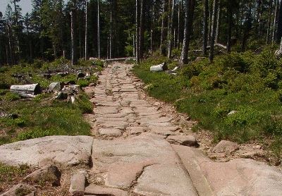
While good roads and bridges cut with seeming ease through these regions today, the Central Massif and the Morvan, divided eastern and western France for centuries. Moving northward along the backside of the 1020 kilometer long Central Massif, sits Lyon; and just beyond the city, as the northern tip of the Central Massif falls away, a gap between the mountains develops before Morvan rises up again in the north. Because this area is hilly, defined its boundaries is not straight forward but is the gap is a fairly wide area of at least 50 to 75 square kilometers, .
Militarily, these are the kinds of gaps that armies seek to strike their enemy, but in the past two thousand years, no major advances seemed to have launched by any army through this gap. Why was this? A possible explanation is that this gap is covered by irregular hills and multi-directional valleys, through which the headwaters of the Loire and other rivers form. Many of these headwaters are rivers in their own right, including the Allier, Arroux, Dore, Loire, Nievre, and Sioule Rivers, and each would have created their own fording challenges. Secondly, the valleys may have been swampy until they were drained in the late 18th and early 19th centuries. This would have made the movement of equipment substantially difficult.
Northward from this gap, one will encounter the heavily wooded hills of Morvan Massif. This too stood as yet another obstacle to travel. Although the total elevation of the Morvan is not overly high, with its highest peaks being roughly 1000 meters, it can be rugged, densely wooded, and has an imposing breadth of 35 kilometers. Along the eastern foothills of the Morvan, is where the vineyards of the Côte d’Or are located.

Via Agrippa: the first well-established roads in Eastern France
The first Roman routes, out of simplicity, skirted the Central Massif. To the Massif’s south, the road hugged the Mediterranean coastline as it moves westward. At Arelate (Arles), which became an important Roman port and trading city, the Via Domita ran toward the Iberian Penisula, where it met with the Via Aquitania, which drove northwest toward Burdigala (Bordeaux) on the Atlantic coast. To move northward from Arelate, the road system of the Via Agrippa began. Constructed for movement of legions to conqueror and control the unsettled regions east of the Central Massif, Roman leaders decided to establish Lugdunum (Lyon) as the hub of the expansive Via Agrippa road network. Archaeologists Ulrich Erdmann writes that the “geography of Burgundy was advantageous to the development of a strong infrastructure with busy roads from Lyon, the capital of the province, to Paris and the Channel ports, and to the Rhine.” (Ulrich Erdmann 2004) Because of this well-constructed road system, this was certainly the case during Roman times. And much later, the better sections of the road would continue to serve the basic economic needs of the region, right up until the revolution.
The Rise of Lugdunum
That the Roman engineers decided that Via Agrippa should radiate from Lugdunum (Lyon), made the city a very important trading hub. Lyon would link Rome to nearly all of its European provinces, including those in Switzerland, Germany, Northern France, as well as being the most direct route to its most far-flung northern European possessions, including the Netherlands, Belgium, and Britain. It is important to note, that the decision to choose Lyon as the hub of this road system, would impact Burgundy for centuries after the fall of Rome. This road was economic thoroughfare Burgundy would require to maintain its independence over such a long period of time.
In the best of conditions, trade in ancient times was slow, moving at the pace of a draft horse under a heavy load. Couriers and unburdened travelers and may have moved more swiftly, but these long distances required patience. To ease these troubles, Romans built small, well-appointed towns along the route to act as rest stations along the way, catering to the needs of the well-heeled traveler, and others.
Roman Gaul was generally peaceful and stable for centuries, and in fact, legions were generally not stationed there after 15 BC. (Woolf 2000) Around 300 years after Gaul’s submission to Rome, every freeman of Gaul was offered citizenship (212 AD). This was not a special dispensation since it was granted to all lands within the empire, but Gaul was widely considered to be the most acquiescent and accepting of Roman rule.(Erdmann 2004)
The most important route, at least in regards to Burgundy’s connectivity to the rest of Europe, was the main, north-south artery of the Via Agrippa. This road headed north to Dijon, through Langres, and ultimately to the port city of Cologne on the Belgian coast. This was the road which would become instrumental in Burgundy’s wine trade, forever onward.

The conclusion that Lyon-Cologne was the most vital route is based partially on the fact that this road is one we know the most about. It appears far more frequently in literature than any of the other Burgundian roads, and that is true of writings from antiquity, until well after the French revolution. This repeated appearance in writings may have to do with its being the road to Langres, which even today remains an important religious center. Langres had the distinction of being the seat of the Bishop of Roman Catholic church, as well as home to several Catholic religious orders. But this road also appears often this road as a major trading artery. That this can not be said about any other regional road, leads one to draw the conclusion that it was the primary route in and out of Burgundy. We might also assume it was the best-maintained road within Burgundy.
Two other, presumably important roads headed directly westward from Lyon. The first was a route that zigzagged over barren sections the Massif. This spur of the Via Agrippa eventually made its way to Clermont-Ferrand on the reverse side of the Central Massif, then ultimately on to Saintes in southwestern France. This route has been somewhat chronicled over the past two thousand years, but principally as part of the pilgrimage of le Chemin Saint-Jacques. Little of this Roman roadway remains, and its exact route is uncertain. A second spur of the Via Agrippa departed westward from Chalon. This route is referred to as the Lyon-Boulogne, although once it arrives in the Loire Valley it bifurcated, with one branch heading to Saintes, and the other to Boulogne. Unfortunately, we know very little about its route, as much of its roadway has been lost. Over the centuries, the stone, and other road building materials were removed for other uses, and dirt has covered much of the rest. Additionally, little is written about the Lyon-Boulogne, and most our knowledge regarding its existence comes from an ancient Roman map which was discovered in a library in Wormes, Germany in the late 1400’s.
Roman route selection

Roman roads were as part of a larger military conquest strategy. As such, upland routes were chosen for the defensive advantage hills provided, and whenever possible track was selected which were devoid of forestation. Roman columns traveling along these routes were more able to repulse attacks where sight lines were longer. Along these highland routes, way stations were situated on hilltops, as they were far easier to defend.
Conversely, Roman roads avoided valleys, and dense forests, (Planhol, Claval 1994) as both of these terrains presented a tactical disadvantage of not being able to bring the “cohorts to bear.” (Heather 2010) While these overland routes provided security for columns of soldiers and their baggage trains, these overland Roman military roads may have proved difficult enough to deter less disciplined travelers.
But avoiding forested routes may have been more challenging than one might imagine. While today one fifth of France is timber land, consisting of roughly 25% oak trees, when Caesar arrived with his legions in Gaul in 58 BC, it is estimated that two-thirds of France were covered in forests, primarily of oak trees interspersed with thickets. (Thirgood 1971) Wide belts of sacred forests created the natural “frontier zones” which separated the various Gaulish tribes, which only the Druids were allowed to enter. According to J. V. Thirgood, a professor of forestry at the University of British Columbia, the forests held a “psychological dread” for the legionnaires, involving forest warfare and mysticism.

Additionally, the need to find solid ground upon which to build roads was of equal importance. Before the construction of drainage systems, provided by the construction of France’s innumerable canals (ie. Canal du Centre opened in 1792), many of France’s valleys and plains were riddled with marshes. (Grabmayer 2009) This may have made these valley areas between the larger Loire and Saône Valleys unsuited for road construction, not to mention it was likely to have been covered in dense forests. Further, the many rivers that traverse the region would have required the construction several of large and costly bridges.
As much as road construction’s primary purpose was to allow Rome to project its power, its ability to facilitate trade was an expected byproduct of great importance. The roads were an artery of wealth, raw materials, and other valuables, which would economically feed Rome. Both legions and merchants traversed the roads from Gaul to the Italian peninsula, carrying with them all manner of treasure and goods. Caravans were loaded with from gold and silver to less glamorous ores such as lead and tin. They were loaded prized wines from Burgundy which were said to rival the best of the legendary Falernian wines, as well as casks (a Gallic invention) of wine the Rhone, as well as material goods, such prized Samian pottery. There was also a significant movement of grain, which included wheat, barley, and rye, all being transported from France to the Apennine peninsula.
Confusingly, the generic word for ‘grain’ in Latin the is the word “corn”. However, because in English “corn” only refers the vegetable which is indigenous the Americas, some writers have mistakenly understood that corn was grown in Gaul, and traded to the Romans. It obviously was not, since it was not ‘discovered’ by Europeans until sometime after 1492.
Roads dictated by geometrical theorem
Ordered, but inefficient for trade?

Historian Greg Woolf, argues that efficiency and connectivity of these roads were undermined by the Roman’s limited geographical knowledge of France, and that centering its hub on the city of Ludunum (Lyon) was somewhat arbitrary. (Woolf 2000)
This may have been true, but there was at least one other factor at play: the Roman ideology that the intellect must triumph over the random vagaries of nature. As such, the incorporation of Euclidean and Pythagorean theories was widely employed in many aspects of Roman construction, including roads.

The Roman designers conceptualized their roads as a Euclidean geometric equation: thus a road was “a surface is that which has length and breadth only”. The design of any “solid“, is matrix of point, line, and surface, and differs significantly the “solid” object it represents. (de Laguna 1922) Whatever difficulties of these theoretical ideals posed in applying to the actual, physical geography, was left for the on-site surveyors and builders to resolve. Surmounting the peaks, rivers, gorges, as well as marshy valleys, forced those who managed the construction to adjust as necessary. (Legion VIII Augusta) Doubtlessly, there was pressure to complete the job as it was designed, and this may have led to the Roman reputation for overcoming obstacles, rather than building around them.
Having dedicated themselves to build roads to a Euclidean planar, rectilinear model, there are many examples of this in their road construction across the Roman Empire. Stretches of the road will persist for dozens of kilometers, in an unflinchingly straight line. These roads hold straight and true, over a variety of terrains, even when no direct line-of-sight was possible. The most extreme example of this is the Roman road from Bavay to Tongeren (in Belgium), which continues uninterrupted in its straight path for 70 kilometers or 43.5 miles (Gallo, Bishop 2006). This, reasoned the Romans, would allow columns of legionnaires to arrive at a far-flung location in the most expedient, and least exhausted fashion.
To accomplish this feat of building long, dead straight stretches of road, Roman surveyors made visual sightings (of up to six miles) at night, by using fires. Where line-of-sight was not possible, surveyors attained sighting from hilltop to hilltop and utilizing theorems of similar triangles, enabling them to maintain their road’s undeviating course, with remarkable precision (Gallo, Bishop 2006).
No doubt, the Romans over thought their roads, in that It is easy to see how this might prove problematic, in bypassing cities, or not connecting cities with did not fit into their intellectual sense of organization, and might delay a Roman legion’s arrival to a strategic location.
The consequence of Roman road design on a post-Roman France
Just as Gaulish tribes did not coalesce as a single body until the Romans artificially did so by force, once the Romans were gone, France once again splintered into its regional tribes once the Rome fell. No doubt, regional rulers, such as the Frankish King Clovis I, who triumphed over the last Roman military commander in Gaul, would have found the organizational structure of these roads frustrating. It is clear they inhibited movement of goods and communication in almost any direction that wasn’t en route to Rome. For this reason, Roman roads greatly dictated the regional trading partners. For example, travel from Reims, north of Paris to points southwest of Paris, such as Chartes, was extremely circuitous and would have discouraged trading and communication between these two areas within central France. One has to wonder if this de facto subdivision of France, was actually by Roman design, with the intent of keeping populations divergent, and unable to unify, thus making possible rebellions less viable.
By the Middle Ages, the roads of the Via Agrippa were in poor condition despite their immaculate construction. The efficient infrastructure necessary to maintain them had been lost well before the fall of the Roman Empire, which had been in a long period of decline.**
*King Clovis I, who would triumph over Syagrius, the last Roman military command in Gaul, who had held out a decade after Rome itself had fallen. (**) This would finally happen when Rome’s own mercenary armies, consisting largely soldiers of the Germanic Visigoth tribes, breached the walls of Rome in 476 A.D.

Roads and travel in the Middles Ages
 To write so extensively of the design and construction of the Via Agrippa is not to imply that roads were not built during the Middle Ages. But many of these roads were poorly constructed and degraded quickly. This meant that travel upon them became difficult not long after they were built, due to the marginal effort and low-grade materials generally committed to European road construction during the Middle Ages. Too often, little more technique was employed than clearing enough of the brush and trees so that carts could pass. Dust was a problem in the summer, and with periods of heavy rainfall, these rutted roads become deeply muddied, and often becoming impassable.
 More important roads, perhaps as those which linked important holdings of the crown, cities with Duchés, or within Comtés, were built to higher standards. For these roads, workers used lime-infused dirts, like marl or fullers’ earth. (Friedman, Figg 2013) Lime (calcium) can have the capacity to stabilize wet earth by disrupting the alignment of the platelets in clay. This change in soil structure allows the soil to drain better.
These calcium-rich materials were apparently valuable, however, and were sometimes pilfered right from the center of the roadway. The result was that thieves created very large potholes, which, depending on their size and location, could seriously impede travel. Worse, after heavy rains, these pits would fill with water. With murky water obscuring their depth, these potholes became traps for the unaware traveler. Drownings did occur. (Friedman, Figg 2013)
Road fatalities were fairly common over the centuries, occurring when wagons or carts crashed or overturned. (Grabmayer 2009) The Encyclopedia of “Trade, Travel, and Exploration in the Middle Ages”, almost humorously refers to these as “traffic accidents”, and both Friedman & Figg’s text, and Grabmayer’s paper note that numerous such deaths appear in “coroner” records.
Accidents were caused by the carts being flipped, spooked draft animals as the Friedman & Figg cite. Without a doubt, poor cart construction, wear, and fatigue of the cart or wagon, in conjunction with overloading and poor weight distribution, also played a part in these accidents. But they would have been compounded exponentially by travel on these poor roads.
Roads of cultures
How roads were built, and how they were used, both represented a vast difference in culture between the Romans and the Gallic people. Paved Roman roads* were slippery for animals when it rained, and in general were hard on the hoofs of unshod animals. The Roman response was to find a solution. Their answer was fit horses and oxen with what was referred to as a hipposandal: special sandals were constructed from iron plates, and these plates were tied to the animals hooves by leather straps (Bakels 2009), Of course, the medieval Frenchman had no such sandals, and may not have even been interested in obtaining them. As a habit, Gallic travelers tended to avoid these sections of road, particularly when utilizing hoofed animals. So instead of using the roads as intended, the Gauls drove their carts on the footpaths which ran parallel to the center roadway. (Grabmayer 2000) This caused other traffic, particularly those on foot, to create new impromptu paths, which also ran parallel to the Roman road. The practice of using multiple parallel paths to the old Roman roads expanded considerably as the Via Agrippa continued to deteriorate. and becoming increasingly difficult to navigate even for those on foot.

Johann Grabmeyer writes that across a plain on which a Roman road traversed, as many as one hundred, more or less parallel paths might exist. Grabmayer does not cite this source, but the awareness that ancient historians and authors were prone to exaggeration, might be appropriate to keep in mind here. In any case, the point is clear, where the citizens of Ancient Rome had been ordered, purposeful, and methodical, the Frenchmen of the middle ages often sought their own road.
In another point of distinction, the Roman approach to road construction was to tackle obstacles head-on. By utilizing their superior engineering skills, and probably with the heavy use of slave labor, Roman road builders, built over, or removed impediments, whereas their Gallic counterparts of medieval France typically chose to avoid obstacles altogether. For instance, as Roman bridges eventually washed away due to a combination of neglect and flooding, the medieval nobleman rarely concluded that the bridge should be rebuilt, which would incur a major expense. Instead, it was typically decided that the road would perform a detour to an easier crossing point. (Grabmayer 2000) Unlike the Roman roads which had been built a prescribed width, and constructed in a specific manner to withstand both heavy traffic and inclement weather,
Also pointing to these cultural differences, as medieval roads were forced to cross overland routes, where obstacles are many and options to deviate are few, the many paths created ad hoc by travelers often become one path which became narrow, deeply rutted and increasingly risky. This was very different from the Roman roads which moved over similar terrain, as all Roman roads were built a prescribed width and constructed a specific manner to withstand both heavy traffic and inclement weather over a long period of time, with minimal maintenance being required.
*only some Roman roads were paved.

The rise of brigands
The dangers of travel in the 14th and 15th centuries were elevated substantially due to the marked increase in banditry. Dmitry Shlapentokh writes that earlier in the Middle Ages, weapons, warfare, and violence had been the exclusive domain of the nobles. This was by design, the entire existence of the noblesse de l’épée (nobles of the sword) was predicated on the protection of his lands, and thus his people. But it was precisely this long association of violence with social superiority and a higher social standing, which would prove to have very negative consequences.
As the Middle Ages came to a close, major socio-economic changes were occurring, not the least of which was that The Hundred Years War had democratized warfare. Violence was no longer the strict domaine of the nobles. Weapons, which not only had the common man been prohibited from owning, but were far too expensive to procure, widely now available and inexpensive after generations of war. The sword, the weapon most equated to that of the noble, accordingly became the preferred weapon the bandit. Not only was the sword effective, but it symbolized both power and social prestige, as did, unfortunately, the weapon’s use. (Shlapentokh 2008)
Chronic war, the weak ineffective authority of the nobility, unreliable law enforcement, all led to a lack of security and a period of extreme uncertainty. For over three centuries, bandits robbed and murdered in a widespread fashion, making both travel and trade very dangerous. Still, merchants and travelers persisted. Banding together in caravans, they either armed themselves, or would hire armed escorts, to attempts to discourage attacks and make safe passage.

Deterrents to road construction
While one might assume that centuries of living under Roman rule might have instilled the idea that good roads were a key factor in the projection of power, Gallic rulers never appeared to grasp this concept. The was little effort to improve the connectivity of their cities and points of trade and create the ability to travel in all but the worst weather conditions. According to Hugh Chisholm’s surprisingly in-depth 1910 edition of Encyclopedia Britannica, that, although various Gallic monarchs in post Roman-Gaul attempted to maintain the “administrative machinery of the Romans”, that it proved to be “too delicate to be handled by the barbarians”. This statement, however, rings somewhat hollow in its dismissive nature, as many of the administrative and municipal positions had been held by upper-class Gaulish people, for at least a century or more. As such, it is assumed by many historians that Roman thought, and Roman tradition had been interwoven into at least the upper class of Roman-Gallo society. These were not barbarians.

It is likely that the greatest obstacle to systematic road construction was the divisive nature of the noblesse de l’épée (Nobles of the Sword). From the time Viking invasions in the 9th and 10th centuries, power in France would be decentralized, with the king and kingdom playing a weak economic and political role. The ducs and comtés would preside quite independently, as sovereigns over their own lands. The farther from Paris the locale, the more the nobles were apt to chaff at the authority of the king. Rivalries between nobles could be fierce, and open warfare occasionally occurred between what were essentially small countries.*
Antagonism between neighboring nobles could create impassible trade barriers for merchants. Even the borders between etats (estates) were open, the nobility presented substantial financial deterrents to trade. High tolls were imposed upon merchants by each Comté (County) or Duché along their route. Other deterrents included the right of preemption, meaning a noble had the first right to buy the trader’s wares at a “beneficial” price, (Middleton 2005), as well as taxes which may have been imposed by nobles upon the final sale.
For those who understood the economic and political benefits of an effective road system, the decentralized power base within France created a complex, three-part chicken or the egg scenario. In order to build a national road system, the king needed enough economic and political clout to strengthen and centralize the government. To fill the treasury, and gain that political and economic power, robust trade would be required. Yet the lack of lack of cooperation between provincial nobles derailed both trade any hope of constructing a national road system.
(*) National borders were not as they are today. While technically the King of France presided over all of the various lands within France, the actual extent of this unity can be seen in the fact that some powerful nobles controlled Duchés and Comtés within the King’s area of control, and as well as one or more Duché and Comté outside of France. Marriages were arranged for the consolidation of regional power, forging alliances, or even truces, with neighboring Duchés or Comtés. This was done en lieu of having any ability to accomplish any substantive diplomacy.
Did France’s agricultural underpinnings lead to nobles to derail trade?
France’s struggle with encouraging trade may have had its roots in the country’s agricultural underpinnings. For the entirety of Gallic history, up until the 1700’s, farming had been the engine of the economy. Seigneurial agricultural lands had provided the food for the cities and employed its rural population, which may have numbered as many 20 million peasants by the end of the 18th century.* While this may not have been a success story, the nobles, even those who had only nominal wealth, were both economically and socially tied to this system. For them, this system was very successful.
The noble classes were completely centrist in their focus. Their own activities of generating income from their estates, and achieving military glory on the battlefield. Whereas they looked upon Bourgeoisie activity of trade with “disdain”. (Stilwell 2005) As such, Nobles would heavily toll the trade which crossed their lands and tax those who traded there. Whether the activities of social-climbing Bourgeoisie and their economic activities were regarded as a threat to the nobles way of life is not clear, but nobles did not allow overland trade to be easy.
French kings, who were essentially the penultimate noble, seemed to share the attitude that trade was definitively not noble. If one were to extend that premise, undoubtedly it would have been viewed as being beneath the needs of France.
Jean-Baptiste Colbert: one hundred years too soon

As the first true theories of economics would be developed until the le Siècle des Lumières (the Enlightenment), few at the time realized the positive impact trade would have on both economic, and political power for those that held it. But Jean-Baptiste Colbert, king Louis XIV’s powerful minister of finances, harnessing trade for the power and glory of France was a nearly singular focus. While some have written that Colbert was was not an innovator, borrowing his ideas from other men, but he was one of the first to employ what amounted to an economic plan, and to do it on a vast scale. Colbert worked in concert with the king in the attempt to wrestle power from the nobility and to centralize the government into an absolutist monarchy. One aspect this was to subjugate the nobles by forcing them to rescind tolls on road travel from industrial regions to the ports. He reduced taxes upon the Third Estate (most notably the bourgeoisie) who owned much of France’s industry as well as this merchant shipping. Far from aiming to slashing and nearly eliminating taxes like modern fiscal conservatives, he aimed at ultimately maximizing them. He is famed for his quote about determining the perfect level of taxation. He said:
“The art of taxation consists in so plucking the goose as to obtain the largest possible amount of feathers with the smallest possible amount of hissing”.
In order to actually get goods from the industrial centers to the ports, Colbert recognized that the roads within central France were in desperate need improvement. Being a fiscally conservative, however, this was to done with the least possible expense to the treasury; so Colbert revived the feudal compulsory requirement of the corvée. The corvée had traditionally required the peasantry to give their time for civic construction projects as part of their seigneurial dues, but Colbert now instituted this on a national level. The journée de travail, or “days of work” were deeply resented by the peasantry for obvious reasons, but in addition the corvée took them out of their fields at critical harvest times. Trade did increase, however, as goods flowed to the ships and harbors.**
Although Colbert presided over his trade policies for over 27 years, and he did truly make a meaningful improvement to France’s road system, as well as accelerate Frances development as a colonial power, economist Richard W. Fulmer writes that his trade reforms were only partially successful. Before his death, Colbert would advocate that France make a ‘quick’, military strike against Holland, in order to break that countries dominance on international trade. As this Rumsfeldian debacle dragged into full on war, Colbert would lose the ear of the King. The war was quickly draining the treasury, pressuring, once again, for the king to raise taxes. Although the sequence & timing regarding the repeal of Colbert’s signature trade reforms is not clear, tolls and regional trade tariffs were being re-instituted in the years surrounding his death in 1683.
Further, criticisms of Colbert were that his infrastructure improvements were limited in their scope, linking only the port cities to industrial centers. None of these new roads, nor relief of the tolls on trade extended outside the center of France. Whether this was an issue of Colbert only attempting what he felt could be accomplished, considering all of the provincial nobility had not yet been subjugated by the king, or if his sole interest in the export of French goods in the international area, is not entirely clear. But the limited programs France did not in any way encourage internal communication or trade. Moreover, he failed to establish any lasting culture trade within France. At the end of Louis XIV’s reign, 30 years after Colbert’s death, not only had all tolls re-established, but they had doubled.
(*) The earliest census at the end of the 17th century were more estimates than counts, but the entire country was judged to be 19 million to 19.5 million people. Some estimates of rural population are given at 80%, but I have not found supporting documentation for this. By the time of the revolution, population had grown substantially to around 27 million. (D. B. Grigg 1980) (**) Colbert, was so successful and so driven, King Louis gave him many state positions, including the Secretary of Naval Affairs. From this pulpit, he ordered harbors and shipyards, and a massive program to build a powerful navy to project France’s power, half a world away.
Breaking the 1,200-year cycle

Unlike overland trade routes which were constricted by heavy tolls and taxes, sea trade had no restrictions beyond the number of merchant ships that could be built. The merchant elites* the need for lumber was extraordinary. So much so, that for many years the proceeds from the royal forests amounted to a full a quarter of the income gained by the royal treasury.(Thirgood 1971) The bourgeoisie, with their seaborne trade, allowed France to flourished as a colonial power, and because France was able to grow as a colonial power, sea trade could continue to expand. Colonial cotton and sugar trade, along with the trader’s French involvement in the triangular African slave trade, was extremely lucrative, and “grew at twice the rate of other external commerce”. (Boulle 1972)
The growth of seaborne merchant trade achieved a successful formula in resolving the “chicken or the egg” dilemma that plagued overland trade. Its success came because at no point did it directly involve the nobility.
Ironically the economic power gained by the expanding sea trade would ultimately release the shackles that had bound trade within the French interior. This happened because it accelerated the French economy enough that it would finally give the French kings the economic and political power necessary to achieve an absolutist state. This, in turn, would loosen the bonds which had restricted overland trade for more than a thousand years. Tolls would be lifted, and road building would finally commence in the early years of the 1700’s.
(*) The term bourgeoisie (the french term for the business class) is handled gently by historians, given usurpation of the term by Karl Marx in the 19th century. Historians who write about the revolution do use the word bourgeoisie, but those writing about bourgeoisie in the sea trade are called merchant elite, in order to not give their writings the appearance of having a political bent.
Up Next: Isolation part 2.1 The Birth of Modern Burgundy: Road Construction after 1715
Reference Sources for Burgundy: History of the Vignerons: The Villages parts I – IV
New sources for Part 2
The Fall of the Roman Empire: A New History, Peter Heather, Pan Macmillan, 2010
Encyclopedia Britannica Eleventh Edition Vol XXVI ed. Hugh Chisholm, Encyclopedia Britannica Company, 1910
Burgundy as part of the Roman empire, Ulrich Erdmann, http://artbourgogne.free.fr/romanburgundy/ 2004
A Historical Geography of France, Xavier de Planhol, Paul Claval, Cambridge University Press, 1994
Roman Surveying, originally published as Elementos de Ingenieria Romana, Isaac Moreno Gallo, Terragona 2004, translated by Brian R. Bishop, Traianvs 2006
The Historical Significance of Oak, J. V. Thirgood, paper, Faculty of Forestry, University of British Columbia
The Western European Loess Belt: Agrarian History, 5300 BC – AD 1000, Corrie C. Bakels, Springer Science & Business Media, 2009
Societal Breakdown and the Rise of the Early Modern State in Europe, Dmitry Shlapentokh, Palgrave Macmillan, 2008
Pilgrimage, Streets, and Traffic from a Cultural Historical Point of View, Johannes Grabmayer (University of Klagenfurt) June 2009
Becoming Roman: The Origins of Provincial Civilization in Gaul, Greg Woolf Cambridge University Press, 2000
Trade, Travel, and Exploration in the Middle Ages: An Encyclopedia, John Block Friedman, Kristen Mossler Figg, Routledge, 2013
Histoire du vin de Bourgogne, Jean-François Bazin, Editions Jean-paul Gisserot 2002
Economic and Social Conditions in France During the Eighteenth Century, Henri Sée Professor, University of Rennes 1927
Early medieval port customs, tolls and controls on foreign trade, Neil Middleton, Blackwell Publishing Ltd 2005
Population Growth and Agrarian Change: A Historical Perspective D.B. Grigg, CUP Archive, 1980
Jean Baptiste Colbert, 1619-1683, Gonçalo L. Fonseca, New School for Social Research, The Schwartz Center for Economic Policy Analysis
Slave Trade, Commercial Organization and Industrial Growth in Eighteenth-Century Nantes, Revue française d’histoire d’outre-mer PH Boulle – 1972
* * * * *
La Côte-d’Or à vol d’oiseau: lettres écrites à M.L. Havin, après la récolte, Auguste Luchet 1858
Gevrey-Chambertin: notice historique, topographique et statistique, suivie de promenade à Fixin, by Henri Vienne 1850
Journal of a Tour through some of the vineyards of Spain and France, James Busby, Sydney 1833
Peasant Proprietors and other selected essays, Lady Frances Parthenope Verney Longmans, Green, 1885 –
L’état de la recherche sur la vigne, le vin et les vignerons en Bourgogne au XVIIIe siècle, Benoit Garnot, 2008
The Peasants and the King in Burgundy, Hilton Root, University of California Press, 1992
Evolution du Métayage en France, L. Durousseau-Dugontie, Impr. Crauffon, 1905
Centre d’Histoire de la Vigne et du Vin, Charlotte Glain-Fromont, Bulletin de liaison Bulletin 30 janv-fev 2012.pdf
LES Climats du vignoble de Bourgogne Dossier de candidature à L’INSCRIPTION SUR LA LISTE DU PATRIMOINE MONDIAL DE L’UNESCO Janvier 2012
Communities of Grain: Rural Rebellion in Comparative Perspective Victor V. Magagna Cornell University Press 1991
Infant and Child Mortality in Eighteenth Century France: A Function of Income? Hajime Hadeishi, Bureau of Economics Federal Trade Commission, cliometrics.org 2010
Harvest Failures, Jennifer Llewellyn and Steve Thompson, 2015 Alphahistory.com
The Peasantry in the French Revolution P. M. Jones, Cambridge University Press, 1988
The Vile and the Noble: On the Relation between Natural and Social Classifications in the French Wine World, Marion Fourcade, Sociological Quarterly 2012
Aristocracy, Antiquity, and History: An Essay on Classicism in Political Thought, A. A. M. Kinneging Transaction Publishers, 1997
Encyclopedia of the Enlightenment By Michel Delon, Routledge 2013
Provincial Power and Absolute Monarchy: The Estates General of Burgundy 1661–1790 Julian Swann, Cambridge University Press 2003
History and Climate: Memories of the Future? Phil D. Jones, A.E.J. Ogilvie, T.D. Davies, K.R. Briffa Springer Science & Business Media, Apr 17, 2013
The Decline of Childhood Mortality Kenneth Hill. Department of Population Dynamics School of Hygiene and Public Health Johns Hopkins University 1990
The Discovery of France: A Historical Geography Graham Robb W. W. Norton & Company, 2008
The Story of French Jean-Benoît Nadeau, Julie Barlow, Macmillan 2008
